Pilar night lights from space
Night Light of Pilar (Paraíba) from space (Brazil) Src. Average luminocity for 10x10km area is 15.8853% and for 50x50km: 9.785%.
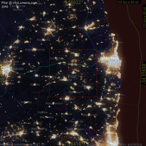
Analysis of Pilar night lights 2016
Square area 10x10 km:
 0%
0%90-99
0.65%80-89
1.95%70-79
0.87%60-69
2.38%50-59
5.41%40-49
3.68%30-39
3.68%20-29
3.9%10-19
7.58%0-9
69.91%Square area 50x50 km:
0.2%90-99
0.5%80-89
1.25%70-79
0.85%60-69
0.8%50-59
2.41%40-49
2.34%30-39
2.39%20-29
2.39%10-19
5.56%0-9
81.33%Clear (daylight) street map image can be seen on geolist.org.
Map coordinates:
6° 34' 9.2" South, 35° 57' 47.3" West
7° 16' 2" South, 35° 15' 36" West
7° 57' 50.9" South, 34° 33' 24.8" West
Some cities around Pilar sort by population:
• Santa Rita
35.5 km =22.1 mi,  61°
61°
• Timbaúba
27.2 km =16.9 mi,  193°
193°
• Itabaiana
10.5 km =6.5 mi,  229°
229°
• Mari
24 km =14.9 mi,  344°
344°
• Pedras de Fogo
21.8 km =13.5 mi,  133°
133°
• Juripiranga
12 km =7.5 mi,  168°
168°
• Cruz do Espírito Santo
23.8 km =14.8 mi,  53°
53°
• Gurinhém
24.1 km =15 mi,  311°
311°
3392127 (p: 7,588)
Sources (retrieved 2019-11-25):
» Earth at Night: Flat Maps 2012, 2016