Itabaiana night lights from space
Night Light of Itabaiana (Paraíba) from space (Brazil) Src. Average luminocity for 10x10km area is 21.0974% and for 50x50km: 8.9273%.
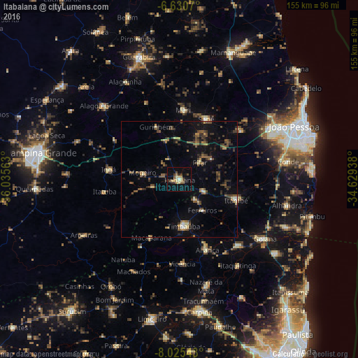
Analysis of Itabaiana night lights 2016
Square area 10x10 km:
 0.22%
0.22%90-99
1.52%80-89
5.84%70-79
2.38%60-69
2.16%50-59
4.11%40-49
4.11%30-39
2.6%20-29
2.16%10-19
13.2%0-9
61.69%Square area 50x50 km:
0.2%90-99
0.43%80-89
1.13%70-79
0.71%60-69
0.9%50-59
2.31%40-49
2.02%30-39
2.19%20-29
2.02%10-19
5.07%0-9
83%Clear (daylight) street map image can be seen on geolist.org.
Map coordinates:
6° 37' 50.5" South, 36° 2' 8.3" West
7° 19' 43" South, 35° 19' 57" West
8° 1' 31.5" South, 34° 37' 45.8" West
Some cities around Itabaiana sort by population:
• Timbaúba
19.7 km =12.2 mi,  175°
175°
• Mari
29.9 km =18.6 mi,  2°
2°
• Macaparana
28.4 km =17.6 mi,  207°
207°
• Pedras de Fogo
25.2 km =15.7 mi,  108°
108°
• Ingá
30.5 km =19 mi,  280°
280°
• Juripiranga
11.5 km =7.1 mi,  115°
115°
• Pilar
10.5 km =6.5 mi,  49°
49°
• Gurinhém
24.9 km =15.5 mi,  335°
335°
3398003 (p: 19,100)
Sources (retrieved 2019-11-25):
» Earth at Night: Flat Maps 2012, 2016