Paripiranga night lights from space
Night Light of Paripiranga (Bahia) from space (Brazil) Src. Average luminocity for 10x10km area is 18.1488% and for 50x50km: 5.9625%.
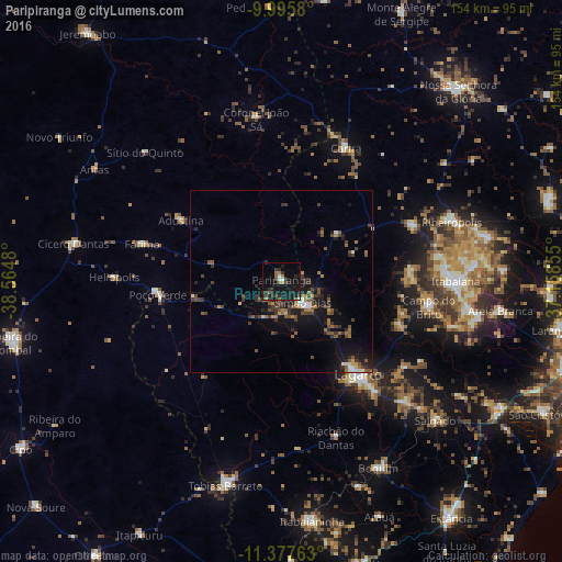
Analysis of Paripiranga night lights 2016
Square area 10x10 km:
 0.62%
0.62%90-99
2.07%80-89
0%70-79
1.24%60-69
3.51%50-59
2.69%40-49
1.65%30-39
6.61%20-29
5.17%10-19
33.68%0-9
42.77%Square area 50x50 km:
0.34%90-99
0.5%80-89
0.24%70-79
0.46%60-69
1.04%50-59
1.33%40-49
1.29%30-39
1.83%20-29
1.64%10-19
5.72%0-9
85.61%Clear (daylight) street map image can be seen on geolist.org.
Map coordinates:
9° 59' 44.9" South, 38° 33' 53.3" West
10° 41' 15" South, 37° 51' 42" West
11° 22' 39.5" South, 37° 9' 30.8" West
Some cities around Paripiranga sort by population:
• Itabaiana
47.7 km =29.6 mi,  89°
89°
• Lagarto
34.5 km =21.4 mi,  137°
137°
• Simão Dias
7.9 km =4.9 mi, 135°
• Poço Verde
35.2 km =21.9 mi,  266°
266°
• Ribeirópolis
51.3 km =31.9 mi,  71°
71°
• Carira
40.3 km =25 mi,  25°
25°
• Campo do Brito
40.6 km =25.2 mi,  97°
97°
• Frei Paulo
38.9 km =24.2 mi, 66°
3454968 (p: 6,965)
Sources (retrieved 2019-11-25):
» Earth at Night: Flat Maps 2012, 2016