Monte Aprazível night lights from space
Night Light of Monte Aprazível (São Paulo) from space (Brazil) Src. Average luminocity for 10x10km area is 11.5833% and for 50x50km: 5.0023%.
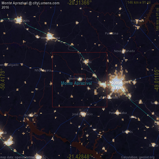
Analysis of Monte Aprazível night lights 2016
Square area 10x10 km:
 0.76%
0.76%90-99
1.7%80-89
1.33%70-79
2.84%60-69
1.7%50-59
0.76%40-49
1.33%30-39
2.46%20-29
0.57%10-19
0.95%0-9
85.61%Square area 50x50 km:
0.48%90-99
0.52%80-89
0.18%70-79
1.03%60-69
0.85%50-59
0.6%40-49
0.93%30-39
0.65%20-29
1.13%10-19
3.12%0-9
90.51%Clear (daylight) street map image can be seen on geolist.org.
Map coordinates:
20° 6' 49.2" South, 50° 25' 2.3" West
20° 46' 21" South, 49° 42' 51" West
21° 25' 42.5" South, 49° 0' 39.8" West
Some cities around Monte Aprazível sort by population:
• São José do Rio Preto
35.2 km =21.9 mi,  98°
98°
• Votuporanga
47.3 km =29.4 mi,  325°
325°
• José Bonifácio
31.3 km =19.4 mi,  175°
175°
• Tanabi
17.6 km =10.9 mi,  22°
22°
• Nova Granada
49.4 km =30.7 mi,  57°
57°
• Bady Bassitt
32.3 km =20.1 mi,  120°
120°
• Guapiaçu
51.4 km =31.9 mi,  92°
92°
• Nhandeara
35.2 km =21.9 mi,  285°
285°
3456866 (p: 16,308)
Sources (retrieved 2019-11-25):
» Earth at Night: Flat Maps 2012, 2016