Alfredo Chaves night lights from space
Night Light of Alfredo Chaves (Espírito Santo) from space (Brazil) Src. Average luminocity for 10x10km area is 6.0379% and for 50x50km: 7.7664%.
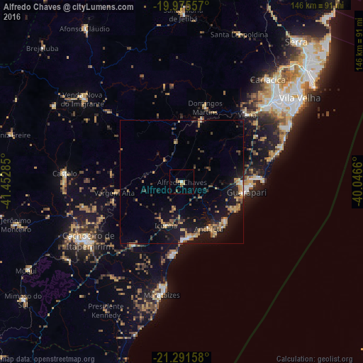
Analysis of Alfredo Chaves night lights 2016
Square area 10x10 km:
 0.57%
0.57%90-99
0.19%80-89
0.95%70-79
0.95%60-69
0.38%50-59
3.79%40-49
0%30-39
0.76%20-29
0%10-19
0%0-9
92.42%Square area 50x50 km:
0.34%90-99
0.38%80-89
1.04%70-79
1.68%60-69
1.08%50-59
1.05%40-49
1.6%30-39
1.01%20-29
1.77%10-19
8.72%0-9
81.33%Clear (daylight) street map image can be seen on geolist.org.
Map coordinates:
19° 58' 32.1" South, 41° 27' 10.3" West
20° 38' 6" South, 40° 44' 59" West
21° 17' 29.7" South, 40° 2' 47.8" West
Some cities around Alfredo Chaves sort by population:
• Guarapari
26.1 km =16.2 mi,  99°
99°
• Viana
37.9 km =23.5 mi,  44°
44°
• Piúma
22.7 km =14.1 mi,  172°
172°
• Itapemirim
42.7 km =26.5 mi,  191°
191°
• Rio Novo do Sul
31.9 km =19.8 mi,  217°
217°
• Domingos Martins
31.6 km =19.6 mi,  17°
17°
• Marechal Floriano
25.7 km =16 mi, 15°
• Iconha
18.7 km =11.6 mi,  199°
199°
3472596 (p: 6,422)
Sources (retrieved 2019-11-25):
» Earth at Night: Flat Maps 2012, 2016