Machado night lights from space
Night Light of Machado (Minas Gerais) from space (Brazil) Src. Average luminocity for 10x10km area is 15.9848% and for 50x50km: 1.9059%.

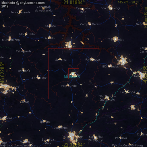
Analysis of Machado night lights 2016
Square area 10x10 km:
 2.08%
2.08%90-99
1.7%80-89
0.76%70-79
3.79%60-69
3.03%50-59
4.17%40-49
0.76%30-39
0.38%20-29
0.76%10-19
3.41%0-9
79.17%Square area 50x50 km:
0.12%90-99
0.22%80-89
0.17%70-79
0.37%60-69
0.61%50-59
0.24%40-49
0.11%30-39
0.18%20-29
0.1%10-19
0.63%0-9
97.26%Clear (daylight) street map image can be seen on geolist.org.
Map coordinates:
21° 1' 11.4" South, 46° 37' 22.3" West
21° 40' 29" South, 45° 55' 11" West
22° 19' 35.9" South, 45° 12' 59.8" West
Some cities around Machado sort by population:
• Alfenas
27.5 km =17.1 mi,  354°
354°
• Campos Gerais
51.7 km =32.1 mi,  18°
18°
• São Gonçalo do Sapucaí
41.3 km =25.7 mi,  125°
125°
• Elói Mendes
37.3 km =23.2 mi,  78°
78°
• Paraguaçu
23.6 km =14.7 mi,  53°
53°
• Campestre
34 km =21.1 mi,  263°
263°
• Botelhos
49.3 km =30.6 mi,  275°
275°
• Areado
42.2 km =26.2 mi,  326°
326°
3458211 (p: 33,002)
Sources (retrieved 2019-11-25):
» Earth at Night: Flat Maps 2012, 2016