Jarinu night lights from space
Night Light of Jarinu (São Paulo) from space (Brazil) Src. Average luminocity for 10x10km area is 29.053% and for 50x50km: 42.0347%.
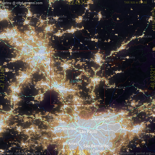
Analysis of Jarinu night lights 2016
Square area 10x10 km:
 0.57%
0.57%90-99
0.19%80-89
0.95%70-79
4.92%60-69
4.73%50-59
10.8%40-49
5.11%30-39
6.25%20-29
16.86%10-19
43.75%0-9
5.87%Square area 50x50 km:
3.59%90-99
4.57%80-89
4.94%70-79
7.76%60-69
9.17%50-59
9.03%40-49
8.37%30-39
9.02%20-29
14.35%10-19
17.59%0-9
11.62%Clear (daylight) street map image can be seen on geolist.org.
Map coordinates:
22° 27' 11.2" South, 47° 25' 53.3" West
23° 6' 5" South, 46° 43' 42" West
23° 44' 47.6" South, 46° 1' 30.8" West
Some cities around Jarinu sort by population:
• Jundiaí
18.5 km =11.5 mi,  239°
239°
• Francisco Morato
20.1 km =12.5 mi,  184°
184°
• Bragança Paulista
25.1 km =15.6 mi,  48°
48°
• Atibaia
18.3 km =11.4 mi,  95°
95°
• Várzea Paulista
15.9 km =9.9 mi,  219°
219°
• Franco da Rocha
24.5 km =15.2 mi, 179°
• Itatiba
15.5 km =9.6 mi,  313°
313°
• Louveira
22.8 km =14.2 mi,  274°
274°
3460068 (p: 17,899)
Sources (retrieved 2019-11-25):
» Earth at Night: Flat Maps 2012, 2016