Alegre night lights from space
Night Light of Alegre (Espírito Santo) from space (Brazil) Src. Average luminocity for 10x10km area is 12.6212% and for 50x50km: 3.0394%.
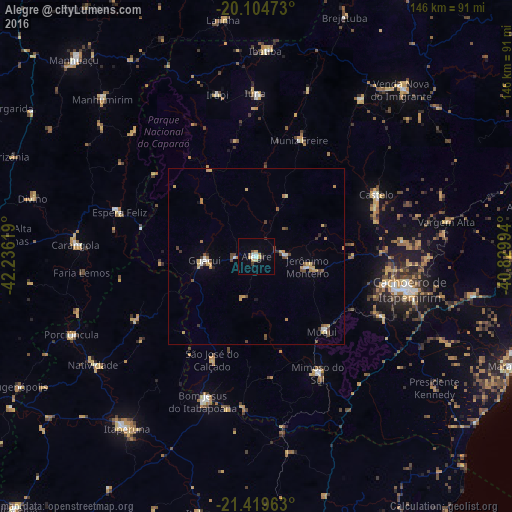
Analysis of Alegre night lights 2016
Square area 10x10 km:
 1.89%
1.89%90-99
1.14%80-89
1.7%70-79
2.84%60-69
0.38%50-59
1.52%40-49
0.38%30-39
1.89%20-29
1.89%10-19
0.19%0-9
86.17%Square area 50x50 km:
0.3%90-99
0.25%80-89
0.45%70-79
0.72%60-69
0.26%50-59
0.35%40-49
0.65%30-39
0.34%20-29
0.38%10-19
0.14%0-9
96.18%Clear (daylight) street map image can be seen on geolist.org.
Map coordinates:
20° 6' 17" South, 42° 14' 10.3" West
20° 45' 49" South, 41° 31' 59" West
21° 25' 10.7" South, 40° 49' 47.8" West
Some cities around Alegre sort by population:
• Bom Jesus do Itabapoana
43.9 km =27.3 mi,  200°
200°
• Castelo
40.4 km =25.1 mi,  63°
63°
• Guaçuí
15.3 km =9.5 mi,  265°
265°
• Mimoso do Sul
37.6 km =23.4 mi,  152°
152°
• Espera Feliz
40.9 km =25.4 mi,  287°
287°
• Muniz Freire
35.6 km =22.1 mi,  20°
20°
• São José do Calçado
31.7 km =19.7 mi, 203°
• Jerônimo Monteiro
14.6 km =9.1 mi,  101°
101°
3472666 (p: 19,757)
Sources (retrieved 2019-11-25):
» Earth at Night: Flat Maps 2012, 2016