Itororó night lights from space
Night Light of Itororó (Bahia) from space (Brazil) Src. Average luminocity for 10x10km area is 6.6529% and for 50x50km: 1.7257%.
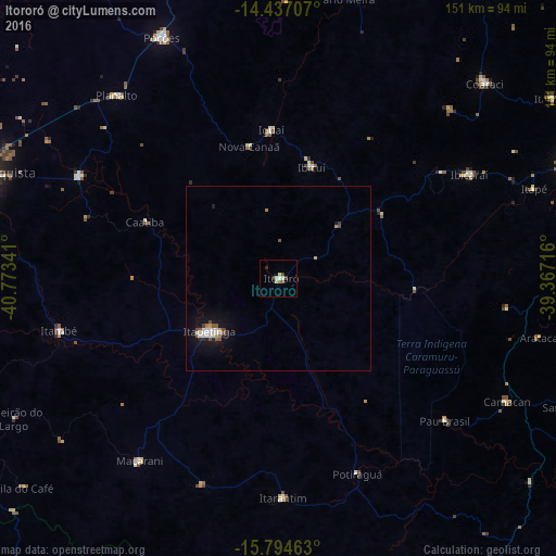
Analysis of Itororó night lights 2016
Square area 10x10 km:
 0.21%
0.21%90-99
1.45%80-89
2.48%70-79
0%60-69
0%50-59
1.65%40-49
1.03%30-39
0.62%20-29
1.65%10-19
0%0-9
90.91%Square area 50x50 km:
0.21%90-99
0.42%80-89
0.17%70-79
0.11%60-69
0.12%50-59
0.31%40-49
0.26%30-39
0.06%20-29
0.26%10-19
1.28%0-9
96.8%Clear (daylight) street map image can be seen on geolist.org.
Map coordinates:
14° 26' 13.5" South, 40° 46' 24.3" West
15° 7' 1" South, 40° 4' 13" West
15° 47' 40.7" South, 39° 22' 1.8" West
Some cities around Itororó sort by population:
• Itapetinga
24 km =14.9 mi,  232°
232°
• Poções
72.6 km =45.1 mi,  334°
334°
• Itambé
61.1 km =38 mi,  256°
256°
• Ibicaraí
58.9 km =36.6 mi,  61°
61°
• Iguaí
40.1 km =24.9 mi,  357°
357°
• Itarantim
60.4 km =37.5 mi,  179°
179°
• Ibicuí
31.9 km =19.8 mi,  16°
16°
• Pau Brasil
59.3 km =36.8 mi,  130°
130°
3460542 (p: 17,324)
Sources (retrieved 2019-11-25):
» Earth at Night: Flat Maps 2012, 2016