Itapecerica night lights from space
Night Light of Itapecerica (Minas Gerais) from space (Brazil) Src. Average luminocity for 10x10km area is 10.6913% and for 50x50km: 1.0013%.
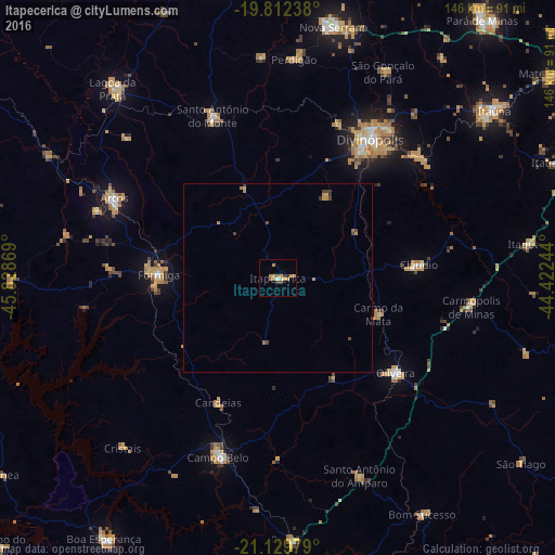
Analysis of Itapecerica night lights 2016
Square area 10x10 km:
 0.38%
0.38%90-99
0.38%80-89
1.33%70-79
5.49%60-69
1.52%50-59
0.76%40-49
1.33%30-39
1.7%20-29
0%10-19
0.38%0-9
86.74%Square area 50x50 km:
0.02%90-99
0.02%80-89
0.07%70-79
0.45%60-69
0.18%50-59
0.09%40-49
0.3%30-39
0.23%20-29
0.01%10-19
0.02%0-9
98.61%Clear (daylight) street map image can be seen on geolist.org.
Map coordinates:
19° 48' 44.6" South, 45° 49' 43.3" West
20° 28' 21" South, 45° 7' 32" West
21° 7' 47.2" South, 44° 25' 20.8" West
Some cities around Itapecerica sort by population:
• Divinópolis
44 km =27.3 mi,  33°
33°
• Formiga
31.4 km =19.5 mi,  271°
271°
• Campo Belo
49.8 km =30.9 mi,  198°
198°
• Oliveira
39.8 km =24.7 mi,  128°
128°
• Arcos
48.1 km =29.9 mi,  296°
296°
• Santo Antônio do Monte
46.3 km =28.8 mi,  337°
337°
• Cláudio
37.6 km =23.4 mi,  85°
85°
• Carmo do Cajuru
48.9 km =30.4 mi,  49°
49°
3460752 (p: 16,684)
Sources (retrieved 2019-11-25):
» Earth at Night: Flat Maps 2012, 2016