Ingá night lights from space
Night Light of Ingá (Paraíba) from space (Brazil) Src. Average luminocity for 10x10km area is 7.9654% and for 50x50km: 3.8461%.
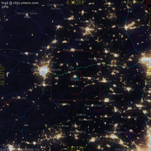
Analysis of Ingá night lights 2016
Square area 10x10 km:
 0%
0%90-99
0.43%80-89
2.16%70-79
0.87%60-69
0.87%50-59
1.73%40-49
1.52%30-39
1.95%20-29
0.43%10-19
2.81%0-9
87.23%Square area 50x50 km:
0%90-99
0.07%80-89
0.54%70-79
0.32%60-69
0.74%50-59
0.98%40-49
0.82%30-39
1.05%20-29
0.89%10-19
1.32%0-9
93.27%Clear (daylight) street map image can be seen on geolist.org.
Map coordinates:
6° 34' 58.3" South, 36° 18' 27.3" West
7° 16' 51" South, 35° 36' 16" West
7° 58' 39.8" South, 34° 54' 4.8" West
Some cities around Ingá sort by population:
• Campina Grande
31 km =19.3 mi,  280°
280°
• Itabaiana
30.5 km =19 mi,  100°
100°
• Alagoa Grande
13.9 km =8.6 mi,  348°
348°
• Alagoa Nova
28.9 km =18 mi,  323°
323°
• Lagoa Seca
30.1 km =18.7 mi,  293°
293°
• Aroeiras
31.5 km =19.6 mi,  201°
201°
• Gurinhém
26.4 km =16.4 mi,  48°
48°
• Fagundes
20.5 km =12.7 mi,  246°
246°
3398224 (p: 8,751)
Sources (retrieved 2019-11-25):
» Earth at Night: Flat Maps 2012, 2016