Gameleira night lights from space
Night Light of Gameleira (Pernambuco) from space (Brazil) Src. Average luminocity for 10x10km area is 6.2707% and for 50x50km: 3.8694%.
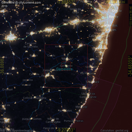
Analysis of Gameleira night lights 2016
Square area 10x10 km:
 0%
0%90-99
0.41%80-89
0.41%70-79
2.48%60-69
0.83%50-59
1.45%40-49
0.21%30-39
0%20-29
0.21%10-19
3.31%0-9
90.7%Square area 50x50 km:
0.11%90-99
0.49%80-89
0.68%70-79
0.4%60-69
0.77%50-59
0.52%40-49
0.49%30-39
0.51%20-29
0.74%10-19
2.04%0-9
93.25%Clear (daylight) street map image can be seen on geolist.org.
Map coordinates:
7° 53' 18.9" South, 36° 5' 23.3" West
8° 35' 4" South, 35° 23' 12" West
9° 16' 44.5" South, 34° 41' 0.8" West
Some cities around Gameleira sort by population:
• Escada
30.8 km =19.1 mi,  35°
35°
• Palmares
25.1 km =15.6 mi,  243°
243°
• Sirinhaém
29.8 km =18.5 mi,  91°
91°
• Ribeirão
7.8 km =4.8 mi,  7°
7°
• Amaraji
23.5 km =14.6 mi,  342°
342°
• Água Preta
20.9 km =13 mi,  229°
229°
• Rio Formoso
26.3 km =16.3 mi,  110°
110°
• Joaquim Nabuco
16.7 km =10.4 mi,  254°
254°
3399132 (p: 19,423)
Sources (retrieved 2019-11-25):
» Earth at Night: Flat Maps 2012, 2016