Rio Formoso night lights from space
Night Light of Rio Formoso (Pernambuco) from space (Brazil) Src. Average luminocity for 10x10km area is 10.0971% and for 50x50km: 7.2355%.
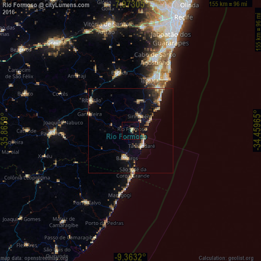
Analysis of Rio Formoso night lights 2016
Square area 10x10 km:
 0%
0%90-99
1.86%80-89
2.27%70-79
0%60-69
0.62%50-59
0.21%40-49
2.27%30-39
1.03%20-29
3.31%10-19
3.72%0-9
84.71%Square area 50x50 km:
0.25%90-99
0.78%80-89
1.17%70-79
1.02%60-69
0.77%50-59
1.1%40-49
1.04%30-39
1.42%20-29
1.2%10-19
5.86%0-9
85.39%Clear (daylight) street map image can be seen on geolist.org.
Map coordinates:
7° 58' 23" South, 35° 51' 57.2" West
8° 40' 7.6" South, 35° 9' 46" West
9° 21' 47.5" South, 34° 27' 34.7" West
Some cities around Rio Formoso sort by population:
• Ipojuca
31.9 km =19.8 mi,  19°
19°
• Escada
35.1 km =21.8 mi,  349°
349°
• Sirinhaém
10.1 km =6.3 mi,  30°
30°
• Barreiros
16.8 km =10.4 mi,  188°
188°
• Ribeirão
29.2 km =18.1 mi,  305°
305°
• Gameleira
26.3 km =16.3 mi,  290°
290°
• Tamandaré
11.9 km =7.4 mi,  144°
144°
• São José da Coroa Grande
25.5 km =15.8 mi,  176°
176°
3390295 (p: 15,518)
Sources (retrieved 2019-11-25):
» Earth at Night: Flat Maps 2012, 2016