Flexeiras night lights from space
Night Light of Flexeiras (Alagoas) from space (Brazil) Src. Average luminocity for 10x10km area is 0.1472% and for 50x50km: 2.6539%.
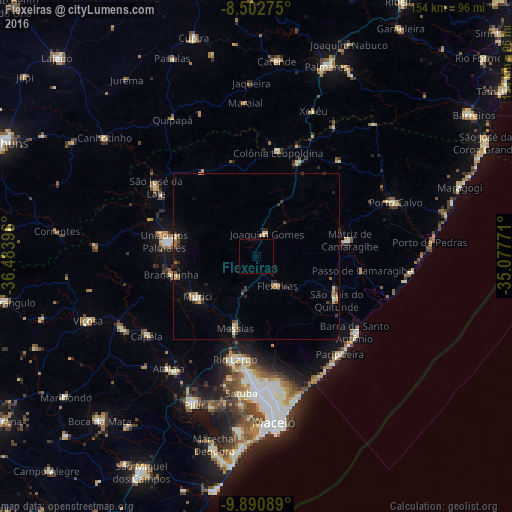
Analysis of Flexeiras night lights 2016
Square area 10x10 km:
 0%
0%90-99
0%80-89
0%70-79
0%60-69
0%50-59
0%40-49
0%30-39
0%20-29
0%10-19
0%0-9
100%Square area 50x50 km:
0.03%90-99
0.47%80-89
0.33%70-79
0.25%60-69
0.51%50-59
0.32%40-49
0.32%30-39
0.55%20-29
0.53%10-19
1.15%0-9
95.54%Clear (daylight) street map image can be seen on geolist.org.
Map coordinates:
8° 30' 9.9" South, 36° 29' 2.3" West
9° 11' 51" South, 35° 46' 51" West
9° 53' 27.2" South, 35° 4' 39.8" West
Some cities around Flexeiras sort by population:
• Rio Largo
32.2 km =20 mi,  194°
194°
• União dos Palmares
27.8 km =17.3 mi,  277°
277°
• São Luís do Quitunde
27.6 km =17.1 mi,  119°
119°
• Murici
21.6 km =13.4 mi,  235°
235°
• Matriz de Camaragibe
27.6 km =17.1 mi,  79°
79°
• Messias
21.7 km =13.5 mi,  197°
197°
• Colônia Leopoldina
32.7 km =20.3 mi,  10°
10°
• Ibateguara
30.5 km =19 mi,  325°
325°
3399571 (p: 7,782)
Sources (retrieved 2019-11-25):
» Earth at Night: Flat Maps 2012, 2016