Matriz de Camaragibe night lights from space
Night Light of Matriz de Camaragibe (Alagoas) from space (Brazil) Src. Average luminocity for 10x10km area is 7.3658% and for 50x50km: 2.6218%.
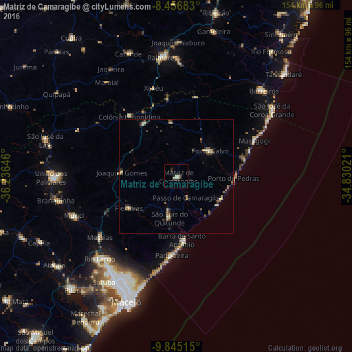
Analysis of Matriz de Camaragibe night lights 2016
Square area 10x10 km:
 0.65%
0.65%90-99
1.52%80-89
0.65%70-79
1.52%60-69
0%50-59
1.73%40-49
0%30-39
3.25%20-29
1.08%10-19
0.43%0-9
89.18%Square area 50x50 km:
0.03%90-99
0.49%80-89
0.32%70-79
0.35%60-69
0.36%50-59
0.49%40-49
0.25%30-39
0.82%20-29
0.48%10-19
0.43%0-9
95.98%Clear (daylight) street map image can be seen on geolist.org.
Map coordinates:
8° 27' 24.6" South, 36° 14' 11.3" West
9° 9' 6" South, 35° 31' 60" West
9° 50' 42.5" South, 34° 49' 48.8" West
Some cities around Matriz de Camaragibe sort by population:
• São Luís do Quitunde
18.8 km =11.7 mi,  189°
189°
• Porto Calvo
19 km =11.8 mi,  51°
51°
• Maragogi
37.5 km =23.3 mi,  65°
65°
• Messias
42.5 km =26.4 mi,  232°
232°
• Colônia Leopoldina
34.2 km =21.3 mi,  322°
322°
• Barra de Santo Antônio
28.3 km =17.6 mi,  174°
174°
• Flexeiras
27.6 km =17.1 mi,  259°
259°
• Novo Lino
29.1 km =18.1 mi,  334°
334°
3395077 (p: 18,705)
Sources (retrieved 2019-11-25):
» Earth at Night: Flat Maps 2012, 2016