Colônia Leopoldina night lights from space
Night Light of Colônia Leopoldina (Pernambuco) from space (Brazil) Src. Average luminocity for 10x10km area is 5.7684% and for 50x50km: 2.0762%.
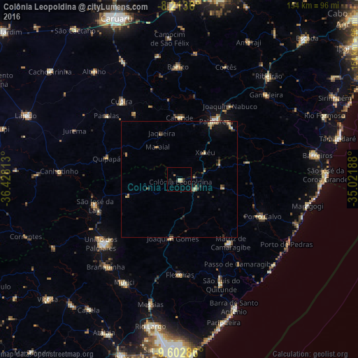
Analysis of Colônia Leopoldina night lights 2016
Square area 10x10 km:
 0%
0%90-99
1.08%80-89
1.52%70-79
0.87%60-69
0.65%50-59
0.22%40-49
0%30-39
0.87%20-29
1.08%10-19
2.38%0-9
91.34%Square area 50x50 km:
0.02%90-99
0.24%80-89
0.37%70-79
0.35%60-69
0.37%50-59
0.21%40-49
0.22%30-39
0.48%20-29
0.56%10-19
0.99%0-9
96.2%Clear (daylight) street map image can be seen on geolist.org.
Map coordinates:
8° 12' 49" South, 36° 25' 41.3" West
8° 54' 32" South, 35° 43' 30" West
9° 36' 10.3" South, 35° 1' 18.8" West
Some cities around Colônia Leopoldina sort by population:
• Palmares
29 km =18 mi,  30°
30°
• Catende
26.9 km =16.7 mi,  1°
1°
• Água Preta
30.9 km =19.2 mi,  43°
43°
• Maraial
16.8 km =10.4 mi,  326°
326°
• Quipapá
32.8 km =20.4 mi,  285°
285°
• Ibateguara
24.6 km =15.3 mi,  253°
253°
• Flexeiras
32.7 km =20.3 mi,  190°
190°
• Novo Lino
8.6 km =5.3 mi,  94°
94°
3401944 (p: 11,913)
Sources (retrieved 2019-11-25):
» Earth at Night: Flat Maps 2012, 2016