Farias Brito night lights from space
Night Light of Farias Brito (Ceará) from space (Brazil) Src. Average luminocity for 10x10km area is 8.6667% and for 50x50km: 2.3205%.
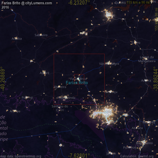
Analysis of Farias Brito night lights 2016
Square area 10x10 km:
 0.43%
0.43%90-99
1.3%80-89
1.73%70-79
0.65%60-69
1.95%50-59
1.52%40-49
0.43%30-39
2.38%20-29
2.16%10-19
0%0-9
87.45%Square area 50x50 km:
0.07%90-99
0.17%80-89
0.26%70-79
0.25%60-69
0.3%50-59
0.61%40-49
0.5%30-39
0.55%20-29
0.58%10-19
0.57%0-9
96.12%Clear (daylight) street map image can be seen on geolist.org.
Map coordinates:
6° 13' 55.5" South, 40° 16' 7.3" West
6° 55' 50" South, 39° 33' 56" West
7° 37' 40.8" South, 38° 51' 44.8" West
Some cities around Farias Brito sort by population:
• Juazeiro do Norte
41.8 km =26 mi,  138°
138°
• Crato
37.9 km =23.5 mi,  152°
152°
• Barbalha
51.2 km =31.8 mi, 145°
• Jucás
45.3 km =28.1 mi,  5°
5°
• Missão Velha
58.6 km =36.4 mi,  127°
127°
• Caririaçu
33.5 km =20.8 mi,  111°
111°
• Assaré
34.7 km =21.6 mi,  280°
280°
• Aurora
66 km =41 mi,  91°
91°
3400497 (p: 11,288)
Sources (retrieved 2019-11-25):
» Earth at Night: Flat Maps 2012, 2016