Assaré night lights from space
Night Light of Assaré (Ceará) from space (Brazil) Src. Average luminocity for 10x10km area is 8.803% and for 50x50km: 1.5047%.
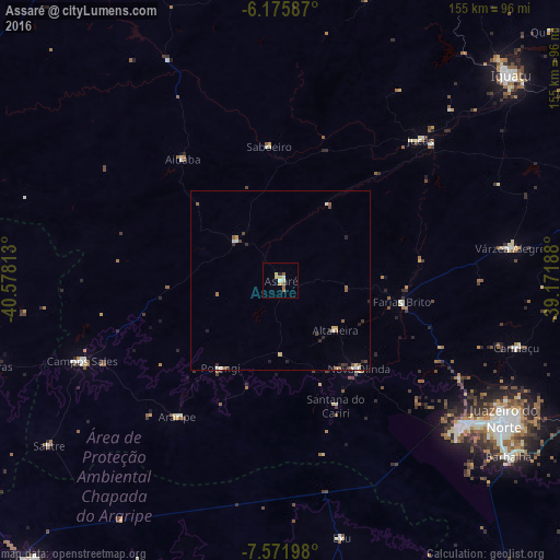
Analysis of Assaré night lights 2016
Square area 10x10 km:
 0.43%
0.43%90-99
1.3%80-89
1.95%70-79
1.73%60-69
1.52%50-59
2.6%40-49
0%30-39
0%20-29
0.87%10-19
0%0-9
89.61%Square area 50x50 km:
0.11%90-99
0.27%80-89
0.18%70-79
0.21%60-69
0.12%50-59
0.42%40-49
0.22%30-39
0.15%20-29
0.35%10-19
0.22%0-9
97.74%Clear (daylight) street map image can be seen on geolist.org.
Map coordinates:
6° 10' 33.1" South, 40° 34' 41.3" West
6° 52' 28" South, 39° 52' 30" West
7° 34' 19.1" South, 39° 10' 18.8" West
Some cities around Assaré sort by population:
• Juazeiro do Norte
72.3 km =44.9 mi,  121°
121°
• Crato
65.1 km =40.5 mi,  127°
127°
• Campos Sales
59.6 km =37 mi,  248°
248°
• Ipueiras
65.9 km =40.9 mi, 254°
• Jucás
54.6 km =33.9 mi,  44°
44°
• Caririaçu
67.9 km =42.2 mi,  105°
105°
• Araripe
47.5 km =29.5 mi,  217°
217°
• Farias Brito
34.7 km =21.6 mi,  100°
100°
3407010 (p: 11,369)
Sources (retrieved 2019-11-25):
» Earth at Night: Flat Maps 2012, 2016