Conchas night lights from space
Night Light of Conchas (São Paulo) from space (Brazil) Src. Average luminocity for 10x10km area is 11.6825% and for 50x50km: 3.4862%.
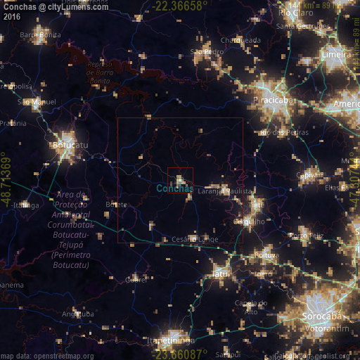
Analysis of Conchas night lights 2016
Square area 10x10 km:
 0.6%
0.6%90-99
0.2%80-89
1.59%70-79
3.17%60-69
2.58%50-59
2.98%40-49
0.79%30-39
1.19%20-29
1.39%10-19
1.79%0-9
83.73%Square area 50x50 km:
0.16%90-99
0.12%80-89
0.43%70-79
0.74%60-69
0.64%50-59
0.55%40-49
0.44%30-39
0.79%20-29
0.5%10-19
2.04%0-9
93.59%Clear (daylight) street map image can be seen on geolist.org.
Map coordinates:
22° 21' 59.7" South, 48° 42' 49.3" West
23° 0' 55" South, 48° 0' 38" West
23° 39' 39.1" South, 47° 18' 26.8" West
Some cities around Conchas sort by population:
• Piracicaba
49.1 km =30.5 mi,  48°
48°
• Botucatu
46.8 km =29.1 mi,  287°
287°
• Tatuí
41 km =25.5 mi,  157°
157°
• Boituva
45.7 km =28.4 mi,  130°
130°
• Cerquilho
32 km =19.9 mi,  121°
121°
• Tietê
31.8 km =19.8 mi,  107°
107°
• Rio das Pedras
45.6 km =28.3 mi,  65°
65°
• Laranjal Paulista
18.2 km =11.3 mi,  102°
102°
3465729 (p: 14,301)
Sources (retrieved 2019-11-25):
» Earth at Night: Flat Maps 2012, 2016