Cícero Dantas night lights from space
Night Light of Cícero Dantas (Bahia) from space (Brazil) Src. Average luminocity for 10x10km area is 11.6074% and for 50x50km: 3.1536%.
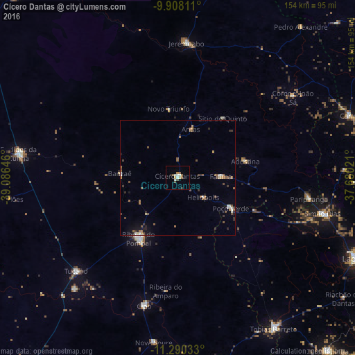
Analysis of Cícero Dantas night lights 2016
Square area 10x10 km:
 1.65%
1.65%90-99
2.48%80-89
0.83%70-79
1.03%60-69
0.83%50-59
3.31%40-49
1.45%30-39
0.83%20-29
0.83%10-19
0%0-9
86.78%Square area 50x50 km:
0.28%90-99
0.43%80-89
0.13%70-79
0.31%60-69
0.61%50-59
0.84%40-49
0.49%30-39
0.47%20-29
0.53%10-19
0.78%0-9
95.12%Clear (daylight) street map image can be seen on geolist.org.
Map coordinates:
9° 54' 29.2" South, 39° 5' 11.3" West
10° 36' 0" South, 38° 22' 60" West
11° 17' 25.2" South, 37° 40' 48.8" West
Some cities around Cícero Dantas sort by population:
• Tucano
59.7 km =37.1 mi,  228°
228°
• Euclides da Cunha
69.9 km =43.4 mi,  278°
278°
• Ribeira do Pombal
30.9 km =19.2 mi,  212°
212°
• Simão Dias
64.4 km =40 mi,  103°
103°
• Jeremoabo
59.3 km =36.8 mi,  349°
349°
• Poço Verde
25 km =15.5 mi,  118°
118°
• Cipó
57.4 km =35.7 mi,  194°
194°
• Paripiranga
57.8 km =35.9 mi, 99°
3466171 (p: 18,317)
Sources (retrieved 2019-11-25):
» Earth at Night: Flat Maps 2012, 2016