Catolé do Rocha night lights from space
Night Light of Catolé do Rocha (Paraíba) from space (Brazil) Src. Average luminocity for 10x10km area is 24.4242% and for 50x50km: 3.3294%.
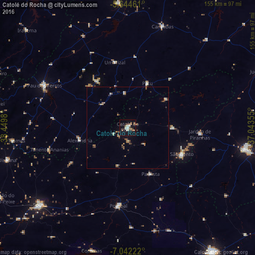
Analysis of Catolé do Rocha night lights 2016
Square area 10x10 km:
 2.6%
2.6%90-99
4.76%80-89
3.03%70-79
0%60-69
3.03%50-59
6.06%40-49
4.11%30-39
0.65%20-29
3.46%10-19
32.25%0-9
40.04%Square area 50x50 km:
0.19%90-99
0.48%80-89
0.21%70-79
0.33%60-69
0.56%50-59
0.75%40-49
0.52%30-39
0.43%20-29
0.8%10-19
1.56%0-9
94.17%Clear (daylight) street map image can be seen on geolist.org.
Map coordinates:
5° 38' 40.6" South, 38° 26' 59.3" West
6° 20' 38" South, 37° 44' 48" West
7° 2' 32" South, 37° 2' 36.8" West
Some cities around Catolé do Rocha sort by population:
• São Bento
6.7 km =4.2 mi,  356°
356°
• Pombal
47.8 km =29.7 mi,  187°
187°
• Jardim de Piranhas
43.8 km =27.2 mi,  95°
95°
• Alexandria
30.7 km =19.1 mi,  255°
255°
• Patu
28.7 km =17.8 mi,  25°
25°
• Umarizal
40 km =24.9 mi,  349°
349°
• Belém do Brejo do Cruz
29 km =18 mi,  53°
53°
• Serra Branca
61.2 km =38 mi,  249°
249°
3402465 (p: 19,812)
Sources (retrieved 2019-11-25):
» Earth at Night: Flat Maps 2012, 2016