Alexandria night lights from space
Night Light of Alexandria (Rio Grande do Norte) from space (Brazil) Src. Average luminocity for 10x10km area is 7.3658% and for 50x50km: 2.1256%.
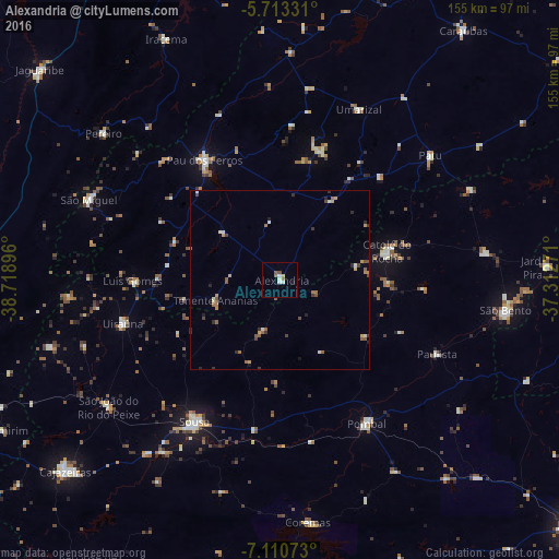
Analysis of Alexandria night lights 2016
Square area 10x10 km:
 0.22%
0.22%90-99
3.03%80-89
0.22%70-79
0.87%60-69
1.73%50-59
0.87%40-49
0.87%30-39
0%20-29
0%10-19
0.87%0-9
91.34%Square area 50x50 km:
0.06%90-99
0.38%80-89
0.13%70-79
0.38%60-69
0.35%50-59
0.57%40-49
0.35%30-39
0.24%20-29
0.46%10-19
0.19%0-9
96.88%Clear (daylight) street map image can be seen on geolist.org.
Map coordinates:
5° 42' 47.9" South, 38° 43' 8.3" West
6° 24' 45" South, 38° 0' 57" West
7° 6' 38.6" South, 37° 18' 45.8" West
Some cities around Alexandria sort by population:
• Sousa
45.1 km =28 mi,  211°
211°
• São Bento
32.7 km =20.3 mi,  63°
63°
• Pombal
46.3 km =28.8 mi,  149°
149°
• Catolé do Rocha
30.7 km =19.1 mi,  75°
75°
• Juàzeirinho
45.1 km =28 mi,  184°
184°
• Umarizal
51.9 km =32.2 mi,  25°
25°
• Serra Branca
30.8 km =19.1 mi,  244°
244°
• Uiraúna
45.3 km =28.1 mi,  254°
254°
3407977 (p: 9,769)
Sources (retrieved 2019-11-25):
» Earth at Night: Flat Maps 2012, 2016