Boquim night lights from space
Night Light of Boquim (Sergipe) from space (Brazil) Src. Average luminocity for 10x10km area is 20.7619% and for 50x50km: 13.64%.
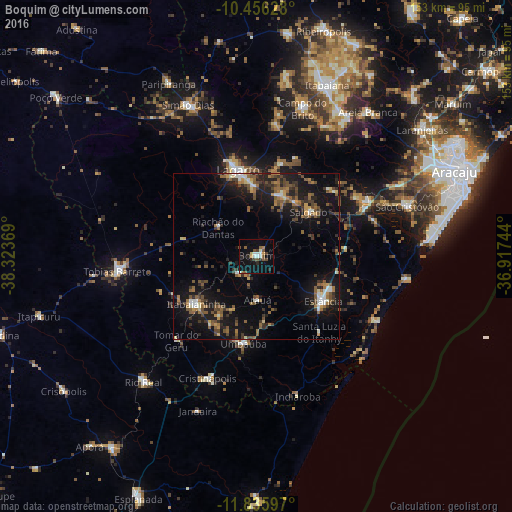
Analysis of Boquim night lights 2016
Square area 10x10 km:
 2.81%
2.81%90-99
3.46%80-89
0.65%70-79
1.95%60-69
1.52%50-59
4.98%40-49
3.68%30-39
1.95%20-29
4.76%10-19
14.29%0-9
59.96%Square area 50x50 km:
0.85%90-99
1.46%80-89
0.73%70-79
1.23%60-69
2.31%50-59
3.42%40-49
2.58%30-39
2.67%20-29
3.7%10-19
14.29%0-9
66.75%Clear (daylight) street map image can be seen on geolist.org.
Map coordinates:
10° 27' 22.6" South, 38° 19' 25.3" West
11° 8' 49" South, 37° 37' 14" West
11° 50' 9.5" South, 36° 55' 2.8" West
Some cities around Boquim sort by population:
• São Cristóvão
47.5 km =29.5 mi,  71°
71°
• Estância
24 km =14.9 mi,  124°
124°
• Lagarto
25.7 km =16 mi,  352°
352°
• Tobias Barreto
41.4 km =25.7 mi,  264°
264°
• Itabaianinha
23.3 km =14.5 mi,  232°
232°
• Umbaúba
26.6 km =16.5 mi,  188°
188°
• Cristinápolis
39.4 km =24.5 mi,  201°
201°
• Salgado
20.4 km =12.7 mi,  51°
51°
3468823 (p: 14,848)
Sources (retrieved 2019-11-25):
» Earth at Night: Flat Maps 2012, 2016