Cristinápolis night lights from space
Night Light of Cristinápolis (Sergipe) from space (Brazil) Src. Average luminocity for 10x10km area is 13.7576% and for 50x50km: 5.8706%.
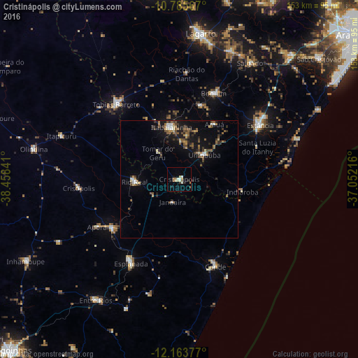
Analysis of Cristinápolis night lights 2016
Square area 10x10 km:
 0.65%
0.65%90-99
3.9%80-89
2.38%70-79
0.22%60-69
2.81%50-59
1.3%40-49
0.87%30-39
0.87%20-29
1.73%10-19
2.81%0-9
82.47%Square area 50x50 km:
0.38%90-99
0.78%80-89
0.42%70-79
0.43%60-69
0.95%50-59
1.43%40-49
1.02%30-39
1.03%20-29
1.11%10-19
4.63%0-9
87.84%Clear (daylight) street map image can be seen on geolist.org.
Map coordinates:
10° 47' 8.4" South, 38° 27' 30.3" West
11° 28' 32" South, 37° 45' 19" West
12° 9' 49.6" South, 37° 3' 7.8" West
Some cities around Cristinápolis sort by population:
• Estância
41.5 km =25.8 mi,  56°
56°
• Rio Real
19.4 km =12.1 mi,  266°
266°
• Esplanada
41.2 km =25.6 mi,  210°
210°
• Itabaianinha
22.7 km =14.1 mi,  350°
350°
• Conde
40.8 km =25.4 mi,  157°
157°
• Boquim
39.4 km =24.5 mi,  21°
21°
• Acajutiba
35.3 km =21.9 mi,  233°
233°
• Umbaúba
14.8 km =9.2 mi,  46°
46°
3465154 (p: 6,430)
Sources (retrieved 2019-11-25):
» Earth at Night: Flat Maps 2012, 2016