Jacaraú night lights from space
Night Light of Jacaraú (Paraíba) from space (Brazil) Src. Average luminocity for 10x10km area is 12.3355% and for 50x50km: 6.6342%.
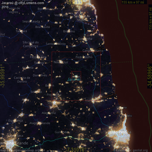
Analysis of Jacaraú night lights 2016
Square area 10x10 km:
 0.43%
0.43%90-99
1.3%80-89
0.87%70-79
0.87%60-69
1.95%50-59
3.03%40-49
3.9%30-39
2.6%20-29
2.38%10-19
1.3%0-9
81.39%Square area 50x50 km:
0.1%90-99
0.43%80-89
0.95%70-79
0.58%60-69
0.9%50-59
1.29%40-49
1.53%30-39
1.5%20-29
2.2%10-19
3.47%0-9
87.05%Clear (daylight) street map image can be seen on geolist.org.
Map coordinates:
5° 54' 47.9" South, 35° 59' 45.3" West
6° 36' 44" South, 35° 17' 34" West
7° 18' 36.6" South, 34° 35' 22.8" West
Some cities around Jacaraú sort by population:
• Mamanguape
31.2 km =19.4 mi,  143°
143°
• Nova Cruz
21.6 km =13.4 mi,  313°
313°
• Canguaretama
31.5 km =19.6 mi,  35°
35°
• Belém
28 km =17.4 mi,  251°
251°
• Rio Tinto
31.6 km =19.6 mi,  132°
132°
• Montanhas
14.1 km =8.8 mi,  2°
2°
• Pirpirituba
29.4 km =18.3 mi,  230°
230°
• Pedro Velho
20.8 km =12.9 mi,  22°
22°
3397800 (p: 7,035)
Sources (retrieved 2019-11-25):
» Earth at Night: Flat Maps 2012, 2016