Batalha night lights from space
Night Light of Batalha (Piauí) from space (Brazil) Src. Average luminocity for 10x10km area is 9.7662% and for 50x50km: 2.0111%.
Analysis of Batalha night lights 2016
Square area 10x10 km:
 1.52%
1.52%90-99
2.6%80-89
1.52%70-79
0.43%60-69
0.87%50-59
1.73%40-49
0.43%30-39
1.3%20-29
0.87%10-19
0%0-9
88.74%Square area 50x50 km:
0.15%90-99
0.43%80-89
0.26%70-79
0.33%60-69
0.2%50-59
0.27%40-49
0.16%30-39
0.25%20-29
0.31%10-19
0.54%0-9
97.08%Clear (daylight) street map image can be seen on geolist.org.
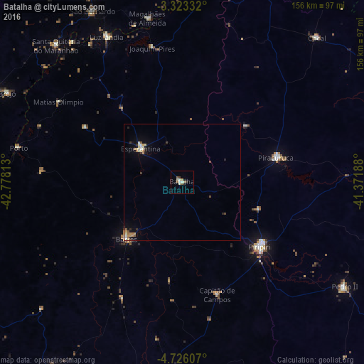
Map coordinates:
3° 19' 24" South, 42° 46' 41.3" West
4° 1' 30" South, 42° 4' 30" West
4° 43' 33.9" South, 41° 22' 18.8" West
Some cities around Batalha sort by population:
• Piripiri
43.1 km =26.8 mi,  129°
129°
• Pedro II
81.5 km =50.6 mi,  123°
123°
• Barras
34.5 km =21.4 mi,  224°
224°
• Esperantina
22.3 km =13.9 mi,  307°
307°
• Piracuruca
42 km =26.1 mi,  75°
75°
• Santa Quitéria do Maranhão
77.1 km =47.9 mi,  317°
317°
• Luzilândia
71.1 km =44.2 mi,  332°
332°
• Porto
71.9 km =44.7 mi,  281°
281°
3406001 (p: 8,744)
Sources (retrieved 2019-11-25):
» Earth at Night: Flat Maps 2012, 2016