Barroquinha night lights from space
Night Light of Barroquinha (Ceará) from space (Brazil) Src. Average luminocity for 10x10km area is 5.3117% and for 50x50km: 1.0279%.
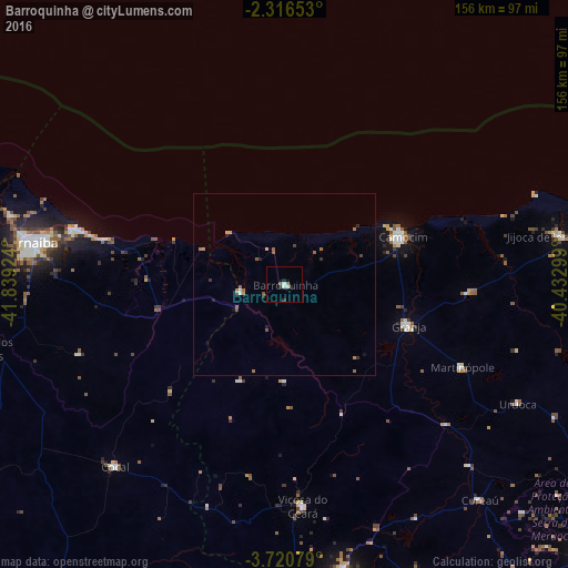
Analysis of Barroquinha night lights 2016
Square area 10x10 km:
 0.43%
0.43%90-99
2.16%80-89
0%70-79
0%60-69
0.87%50-59
0.87%40-49
0%30-39
0%20-29
3.25%10-19
0.22%0-9
92.21%Square area 50x50 km:
0.04%90-99
0.13%80-89
0.08%70-79
0.06%60-69
0.35%50-59
0.35%40-49
0.07%30-39
0.14%20-29
0.29%10-19
0.13%0-9
98.37%Clear (daylight) street map image can be seen on geolist.org.
Map coordinates:
2° 18' 59.5" South, 41° 50' 21.3" West
3° 1' 8" South, 41° 8' 10" West
3° 43' 14.8" South, 40° 25' 58.8" West
Some cities around Barroquinha sort by population:
• Parnaíba
72.3 km =44.9 mi,  280°
280°
• Camocim
35.2 km =21.9 mi,  68°
68°
• Granja
36.2 km =22.5 mi,  108°
108°
• Viçosa do Ceará
60.6 km =37.7 mi,  175°
175°
• Coreaú
78.1 km =48.5 mi,  137°
137°
• Cocal
68.7 km =42.7 mi,  222°
222°
• Luís Correia
61 km =37.9 mi, 284°
• Juá dos Vieiras
60 km =37.3 mi,  197°
197°
3406041 (p: 12,410)
Sources (retrieved 2019-11-25):
» Earth at Night: Flat Maps 2012, 2016