Traipu night lights from space
Night Light of Traipu (Alagoas) from space (Brazil) Src. Average luminocity for 10x10km area is 10.5744% and for 50x50km: 5.4668%.
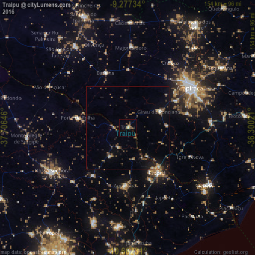
Analysis of Traipu night lights 2016
Square area 10x10 km:
 0.62%
0.62%90-99
0.21%80-89
1.03%70-79
2.27%60-69
2.89%50-59
2.27%40-49
1.24%30-39
0.83%20-29
1.65%10-19
0%0-9
86.98%Square area 50x50 km:
0.11%90-99
0.69%80-89
0.39%70-79
0.67%60-69
0.75%50-59
1.31%40-49
0.94%30-39
0.98%20-29
1.12%10-19
2.95%0-9
90.09%Clear (daylight) street map image can be seen on geolist.org.
Map coordinates:
9° 16' 38.4" South, 37° 42' 23.3" West
9° 58' 14" South, 37° 0' 12" West
10° 39' 44.3" South, 36° 18' 0.8" West
Some cities around Traipu sort by population:
• Arapiraca
44.6 km =27.7 mi,  57°
57°
• Propriá
32.2 km =20 mi,  146°
146°
• Lagoa da Canoa
33 km =20.5 mi, 61°
• Batalha
35.2 km =21.9 mi,  337°
337°
• Aquidabã
34.6 km =21.5 mi,  182°
182°
• Girau do Ponciano
21.4 km =13.3 mi, 63°
• Porto da Folha
30.7 km =19.1 mi,  281°
281°
• Porto Real do Colégio
29.9 km =18.6 mi,  143°
143°
3386198 (p: 8,427)
Sources (retrieved 2019-11-25):
» Earth at Night: Flat Maps 2012, 2016