Porto Real do Colégio night lights from space
Night Light of Porto Real do Colégio (Alagoas) from space (Brazil) Src. Average luminocity for 10x10km area is 41.7645% and for 50x50km: 9.0128%.
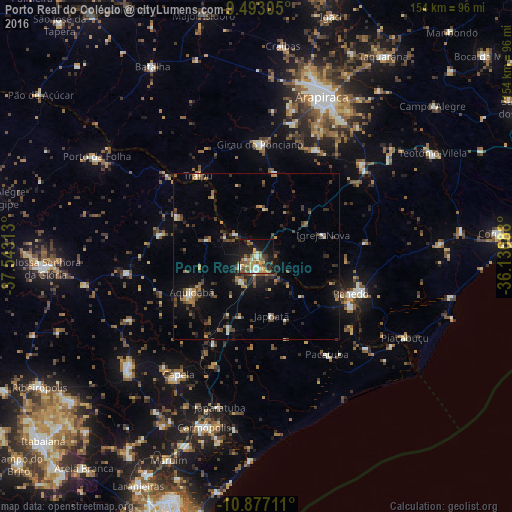
Analysis of Porto Real do Colégio night lights 2016
Square area 10x10 km:
 3.1%
3.1%90-99
7.44%80-89
3.51%70-79
11.78%60-69
5.37%50-59
10.12%40-49
6.82%30-39
3.31%20-29
7.02%10-19
30.37%0-9
11.16%Square area 50x50 km:
0.29%90-99
1.13%80-89
0.51%70-79
1.24%60-69
1.19%50-59
1.98%40-49
1.79%30-39
1.77%20-29
2.25%10-19
6.28%0-9
81.58%Clear (daylight) street map image can be seen on geolist.org.
Map coordinates:
9° 29' 35" South, 37° 32' 35.3" West
10° 11' 9" South, 36° 50' 24" West
10° 52' 37.6" South, 36° 8' 12.8" West
Some cities around Porto Real do Colégio sort by population:
• Penedo
30.1 km =18.7 mi,  112°
112°
• Propriá
2.8 km =1.7 mi,  180°
180°
• Lagoa da Canoa
41.1 km =25.5 mi,  15°
15°
• Neópolis
32.2 km =20 mi,  117°
117°
• Aquidabã
22.2 km =13.8 mi,  241°
241°
• Girau do Ponciano
33.6 km =20.9 mi,  2°
2°
• São Sebastião
42 km =26.1 mi,  48°
48°
• Traipu
29.9 km =18.6 mi,  323°
323°
3452671 (p: 6,001)
Sources (retrieved 2019-11-25):
» Earth at Night: Flat Maps 2012, 2016