Angatuba night lights from space
Night Light of Angatuba (São Paulo) from space (Brazil) Src. Average luminocity for 10x10km area is 7.4375% and for 50x50km: 1.2348%.
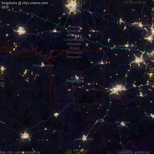
Analysis of Angatuba night lights 2016
Square area 10x10 km:
 0.76%
0.76%90-99
0.76%80-89
0.76%70-79
0.95%60-69
1.52%50-59
1.33%40-49
1.33%30-39
1.7%20-29
0%10-19
2.27%0-9
88.64%Square area 50x50 km:
0.06%90-99
0.06%80-89
0.08%70-79
0.18%60-69
0.31%50-59
0.2%40-49
0.43%30-39
0.36%20-29
0.16%10-19
0.27%0-9
97.89%Clear (daylight) street map image can be seen on geolist.org.
Map coordinates:
22° 50' 35.9" South, 49° 6' 57.3" West
23° 29' 23" South, 48° 24' 46" West
24° 7' 58.8" South, 47° 42' 34.8" West
Some cities around Angatuba sort by population:
• Itapetininga
38.4 km =23.9 mi,  107°
107°
• Botucatu
67.2 km =41.8 mi,  357°
357°
• Tatuí
58.6 km =36.4 mi,  75°
75°
• Capâo Bonito
57.7 km =35.9 mi,  173°
173°
• Paranapanema
33.8 km =21 mi,  289°
289°
• Buri
38.8 km =24.1 mi,  208°
208°
• Itatinga
47.9 km =29.8 mi,  334°
334°
• Conchas
66.9 km =41.6 mi,  37°
37°
3472234 (p: 14,476)
Sources (retrieved 2019-11-25):
» Earth at Night: Flat Maps 2012, 2016