Itatinga night lights from space
Night Light of Itatinga (São Paulo) from space (Brazil) Src. Average luminocity for 10x10km area is 7.2841% and for 50x50km: 3.9663%.
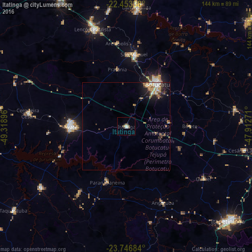
Analysis of Itatinga night lights 2016
Square area 10x10 km:
 1.33%
1.33%90-99
0.95%80-89
1.14%70-79
0.38%60-69
0.76%50-59
0.76%40-49
2.27%30-39
0.76%20-29
0.76%10-19
0.76%0-9
90.15%Square area 50x50 km:
0.49%90-99
0.56%80-89
0.39%70-79
0.79%60-69
0.56%50-59
0.37%40-49
0.76%30-39
0.61%20-29
0.98%10-19
2.01%0-9
92.47%Clear (daylight) street map image can be seen on geolist.org.
Map coordinates:
22° 27' 12.2" South, 49° 19' 8.3" West
23° 6' 6" South, 48° 36' 57" West
23° 44' 48.6" South, 47° 54' 45.8" West
Some cities around Itatinga sort by population:
• Botucatu
29.7 km =18.5 mi,  36°
36°
• Avaré
31.7 km =19.7 mi,  270°
270°
• Lençóis Paulista
59 km =36.7 mi,  341°
341°
• São Manuel
41.5 km =25.8 mi,  6°
6°
• Itaí
59.9 km =37.2 mi,  234°
234°
• Paranapanema
33.5 km =20.8 mi,  199°
199°
• Angatuba
47.9 km =29.8 mi,  154°
154°
• Cerqueira César
56.8 km =35.3 mi,  277°
277°
3460594 (p: 15,696)
Sources (retrieved 2019-11-25):
» Earth at Night: Flat Maps 2012, 2016