Sredets night lights from space
Night Light of Sredets (Burgas) from space (Bulgaria) Src. Average luminocity for 10x10km area is 0.954% and for 50x50km: 2.8545%.
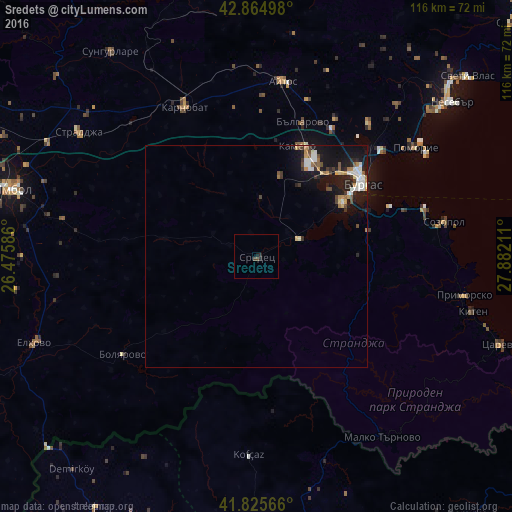
Analysis of Sredets night lights 2016
Square area 10x10 km:
 0%
0%90-99
0%80-89
0%70-79
0%60-69
0%50-59
0%40-49
0.95%30-39
0.32%20-29
0.63%10-19
1.27%0-9
96.83%Square area 50x50 km:
0.36%90-99
0.63%80-89
0.2%70-79
0.33%60-69
0.26%50-59
0.22%40-49
0.4%30-39
0.47%20-29
0.71%10-19
3.34%0-9
93.07%Clear (daylight) street map image can be seen on geolist.org.
Map coordinates:
42° 51' 53.9" North, 26° 28' 33.1" East
42° 20' 50.9" North, 27° 10' 44.3" East
41° 49' 32.4" North, 27° 52' 55.6" East
Some cities around Sredets sort by population:
• Burgas
29.5 km =18.3 mi,  53°
53°
• Yambol
57.7 km =35.9 mi,  285°
285°
• Aytos
39.6 km =24.6 mi,  8°
8°
• Karnobat
37.3 km =23.2 mi,  334°
334°
• Pomorie
44.1 km =27.4 mi,  57°
57°
• Elhovo
54.3 km =33.7 mi,  248°
248°
• Nesebar
57.3 km =35.6 mi, 52°
• Straldzha
49.4 km =30.7 mi,  304°
304°
731016 (p: 9,573)
Sources (retrieved 2019-11-25):
» Earth at Night: Flat Maps 2012, 2016