Steenokkerzeel night lights from space
Night Light of Steenokkerzeel (Flanders) from space (Belgium) Src. Average luminocity for 10x10km area is 75.119% and for 50x50km: 52.7171%.
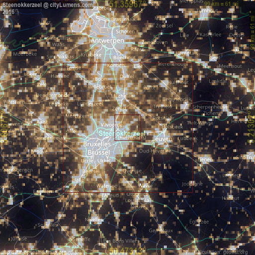
Analysis of Steenokkerzeel night lights 2016
Square area 10x10 km:
 22.83%
90-99
15.13%80-89
7.14%70-79
12.18%60-69
14.15%50-59
13.17%40-49
9.38%30-39
6.02%20-29
0%10-19
0%0-9
0%Square area 50x50 km:
11.69%90-99
9.47%80-89
4.76%70-79
6.27%60-69
8.4%50-59
9.36%40-49
9.78%30-39
10.51%20-29
12.28%10-19
9.95%0-9
7.55%Clear (daylight) street map image can be seen on geolist.org.
Map coordinates:
51° 21' 34.8" North, 3° 48' 24.4" East
50° 55' 6.6" North, 4° 30' 35.6" East
50° 28' 23.3" North, 5° 12' 46.9" East
Some cities around Steenokkerzeel sort by population:
• Vilvoorde
5.7 km =3.5 mi,  280°
280°
• Zaventem
4.7 km =2.9 mi,  213°
213°
• Zemst
8 km =5 mi,  334°
334°
• Kortenberg
4 km =2.5 mi,  143°
143°
• Kraainem
6.9 km =4.3 mi,  204°
204°
• Machelen
4.9 km =3 mi,  259°
259°
• Kampenhout
3.9 km =2.4 mi,  47°
47°
• Diegem
5.9 km =3.7 mi,  246°
246°
2786124 (p: 10,566)
Sources (retrieved 2019-11-25):
» Earth at Night: Flat Maps 2012, 2016