Machelen night lights from space
Night Light of Machelen (Flanders) from space (Belgium) Src. Average luminocity for 10x10km area is 93.7227% and for 50x50km: 54.4093%.
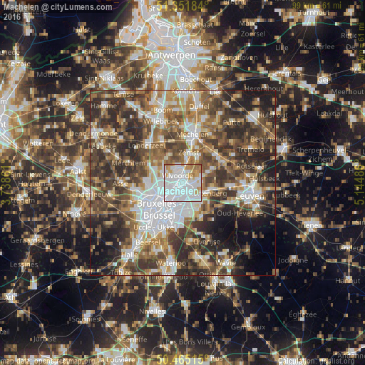
Analysis of Machelen night lights 2016
Square area 10x10 km:
 54.48%
90-99
24.79%80-89
3.92%70-79
8.82%60-69
7.14%50-59
0.84%40-49
0%30-39
0%20-29
0%10-19
0%0-9
0%Square area 50x50 km:
11.64%90-99
9.62%80-89
5.05%70-79
6.42%60-69
8.82%50-59
9.84%40-49
10.93%30-39
11.81%20-29
12.8%10-19
7.7%0-9
5.38%Clear (daylight) street map image can be seen on geolist.org.
Map coordinates:
51° 21' 6.6" North, 3° 44' 19" East
50° 54' 38.2" North, 4° 26' 30.3" East
50° 27' 54.5" North, 5° 8' 41.5" East
Some cities around Machelen sort by population:
• Vilvoorde
2.1 km =1.3 mi,  336°
336°
• Grimbergen
5.5 km =3.4 mi,  298°
298°
• Zaventem
3.7 km =2.3 mi,  143°
143°
• Zemst
8.2 km =5.1 mi,  9°
9°
• Kortenberg
7.5 km =4.7 mi,  107°
107°
• Kraainem
5.8 km =3.6 mi,  160°
160°
• Steenokkerzeel
4.9 km =3 mi,  79°
79°
• Diegem
1.6 km =1 mi,  201°
201°
2791951 (p: 12,252)
Sources (retrieved 2019-11-25):
» Earth at Night: Flat Maps 2012, 2016