Kraainem night lights from space
Night Light of Kraainem (Flanders) from space (Belgium) Src. Average luminocity for 10x10km area is 91.1849% and for 50x50km: 51.7089%.
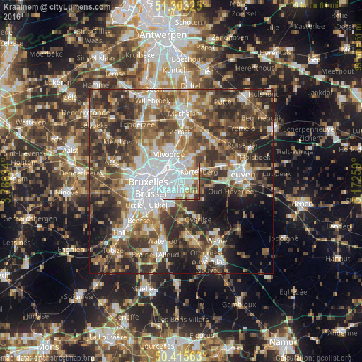
Analysis of Kraainem night lights 2016
Square area 10x10 km:
 56.72%
90-99
19.19%80-89
4.76%70-79
6.44%60-69
6.16%50-59
2.8%40-49
1.26%30-39
1.96%20-29
0.7%10-19
0%0-9
0%Square area 50x50 km:
11.13%90-99
8.92%80-89
4.5%70-79
5.98%60-69
8.13%50-59
9.56%40-49
10.29%30-39
11.22%20-29
13.49%10-19
8.62%0-9
8.16%Clear (daylight) street map image can be seen on geolist.org.
Map coordinates:
51° 18' 11.7" North, 3° 45' 58.8" East
50° 51' 41.6" North, 4° 28' 10.1" East
50° 24' 56.3" North, 5° 10' 21.3" East
Some cities around Kraainem sort by population:
• Vilvoorde
7.9 km =4.9 mi,  339°
339°
• Zaventem
2.5 km =1.6 mi,  5°
5°
• Tervuren
5.2 km =3.2 mi,  143°
143°
• Kortenberg
6.1 km =3.8 mi,  58°
58°
• Wezembeek-Oppem
3 km =1.9 mi, 144°
• Machelen
5.8 km =3.6 mi, 340°
• Steenokkerzeel
6.9 km =4.3 mi,  24°
24°
• Diegem
4.7 km =2.9 mi,  327°
327°
2794016 (p: 12,815)
Sources (retrieved 2019-11-25):
» Earth at Night: Flat Maps 2012, 2016