Saint-Hubert night lights from space
Night Light of Saint-Hubert (Wallonia) from space (Belgium) Src. Average luminocity for 10x10km area is 1.3095% and for 50x50km: 2.9091%.
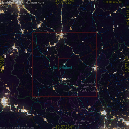
Analysis of Saint-Hubert night lights 2016
Square area 10x10 km:
 0%
0%90-99
0.42%80-89
0.14%70-79
0%60-69
0%50-59
0%40-49
0.56%30-39
0.56%20-29
0.56%10-19
0.56%0-9
97.2%Square area 50x50 km:
0.29%90-99
0.35%80-89
0.23%70-79
0.3%60-69
0.45%50-59
0.47%40-49
0.58%30-39
0.5%20-29
0.75%10-19
1.25%0-9
94.82%Clear (daylight) street map image can be seen on geolist.org.
Map coordinates:
50° 28' 34.6" North, 4° 40' 15.2" East
50° 1' 36" North, 5° 22' 26.4" East
49° 34' 22.2" North, 6° 4' 37.7" East
Some cities around Saint-Hubert sort by population:
• Marche-en-Famenne
22.4 km =13.9 mi,  354°
354°
• Bastogne
24.7 km =15.3 mi,  95°
95°
• Rochefort
18.7 km =11.6 mi,  324°
324°
• Beauraing
31.3 km =19.4 mi,  287°
287°
• Bertrix
20.8 km =12.9 mi,  204°
204°
• Neufchâteau
21.1 km =13.1 mi,  168°
168°
• Nassogne
11.5 km =7.1 mi, 348°
• Paliseul
21.9 km =13.6 mi,  231°
231°
2787407 (p: 5,538)
Sources (retrieved 2019-11-25):
» Earth at Night: Flat Maps 2012, 2016