Liedekerke night lights from space
Night Light of Liedekerke (Flanders) from space (Belgium) Src. Average luminocity for 10x10km area is 61.9566% and for 50x50km: 49.6624%.
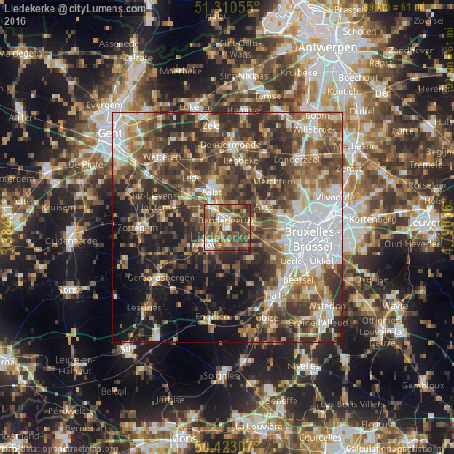
Analysis of Liedekerke night lights 2016
Square area 10x10 km:
 5.88%
5.88%90-99
10.78%80-89
7.28%70-79
10.36%60-69
9.1%50-59
22.13%40-49
21.01%30-39
12.18%20-29
1.26%10-19
0%0-9
0%Square area 50x50 km:
9.73%90-99
8.12%80-89
4.65%70-79
5.67%60-69
7.45%50-59
9.64%40-49
10.99%30-39
10.67%20-29
13.68%10-19
11.43%0-9
7.98%Clear (daylight) street map image can be seen on geolist.org.
Map coordinates:
51° 18' 38" North, 3° 23' 3.5" East
50° 52' 8.1" North, 4° 5' 14.7" East
50° 25' 23.1" North, 4° 47' 26" East
Some cities around Liedekerke sort by population:
• Aalst
8.3 km =5.2 mi,  333°
333°
• Ninove
6.3 km =3.9 mi,  223°
223°
• Asse
9 km =5.6 mi,  59°
59°
• Haaltert
7.4 km =4.6 mi,  304°
304°
• Denderleeuw
2 km =1.2 mi,  335°
335°
• Ternat
5.6 km =3.5 mi,  92°
92°
• Gooik
8.5 km =5.3 mi,  167°
167°
• Sint-Martens-Lennik
8.6 km =5.3 mi,  137°
137°
2792423 (p: 11,980)
Sources (retrieved 2019-11-25):
» Earth at Night: Flat Maps 2012, 2016