Haaltert night lights from space
Night Light of Haaltert (Flanders) from space (Belgium) Src. Average luminocity for 10x10km area is 60.1022% and for 50x50km: 47.1602%.
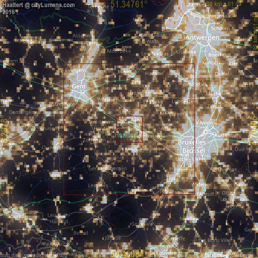
Analysis of Haaltert night lights 2016
Square area 10x10 km:
 7.56%
7.56%90-99
10.36%80-89
10.5%70-79
8.96%60-69
8.12%50-59
15.27%40-49
15.13%30-39
7.42%20-29
14.29%10-19
2.38%0-9
0%Square area 50x50 km:
7.45%90-99
7.8%80-89
4.86%70-79
5.36%60-69
7.35%50-59
9.94%40-49
10.76%30-39
10.87%20-29
13.69%10-19
11.39%0-9
10.52%Clear (daylight) street map image can be seen on geolist.org.
Map coordinates:
51° 20' 51.4" North, 3° 17' 52.1" East
50° 54' 22.8" North, 4° 0' 3.3" East
50° 27' 39" North, 4° 42' 14.6" East
Some cities around Haaltert sort by population:
• Aalst
4.1 km =2.5 mi,  36°
36°
• Ninove
8.9 km =5.5 mi,  168°
168°
• Denderleeuw
5.8 km =3.6 mi,  114°
114°
• Lede
6.7 km =4.2 mi,  351°
351°
• Herzele
8.1 km =5 mi,  254°
254°
• Liedekerke
7.4 km =4.6 mi,  124°
124°
• Wichelen
11.1 km =6.9 mi, 351°
• Sint-Lievens-Houtem
9.8 km =6.1 mi,  278°
278°
2796833 (p: 17,129)
Sources (retrieved 2019-11-25):
» Earth at Night: Flat Maps 2012, 2016