Kortemark night lights from space
Night Light of Kortemark (Flanders) from space (Belgium) Src. Average luminocity for 10x10km area is 13.5027% and for 50x50km: 27.0745%.
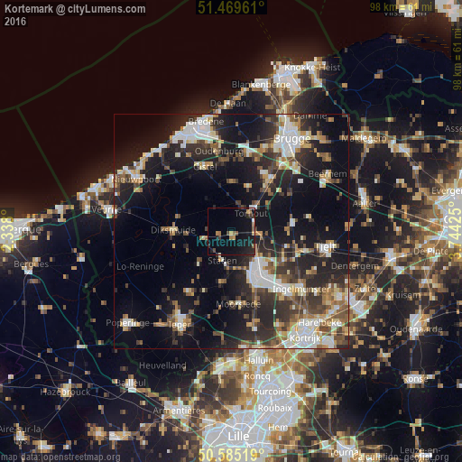
Analysis of Kortemark night lights 2016
Square area 10x10 km:
 0.8%
0.8%90-99
0.4%80-89
0.8%70-79
1.74%60-69
2.41%50-59
2.14%40-49
1.34%30-39
1.6%20-29
5.35%10-19
17.78%0-9
65.64%Square area 50x50 km:
4.15%90-99
5.03%80-89
2.79%70-79
2.54%60-69
2.99%50-59
4.01%40-49
3.62%30-39
4.75%20-29
9.58%10-19
18.77%0-9
41.78%Clear (daylight) street map image can be seen on geolist.org.
Map coordinates:
51° 28' 10.6" North, 2° 20' 16.8" East
51° 1' 46.2" North, 3° 2' 28" East
50° 35' 6.7" North, 3° 44' 39.3" East
Some cities around Kortemark sort by population:
• Roeselare
10.9 km =6.8 mi,  148°
148°
• Torhout
5.8 km =3.6 mi,  46°
46°
• Ichtegem
7.6 km =4.7 mi,  346°
346°
• Staden
6.4 km =4 mi,  196°
196°
• Hooglede
5.9 km =3.7 mi, 150°
• Houthulst
8.5 km =5.3 mi,  228°
228°
• Koekelare
8.1 km =5 mi,  327°
327°
• Lichtervelde
7.6 km =4.7 mi,  86°
86°
2794074 (p: 11,937)
Sources (retrieved 2019-11-25):
» Earth at Night: Flat Maps 2012, 2016