Koekelare night lights from space
Night Light of Koekelare (Flanders) from space (Belgium) Src. Average luminocity for 10x10km area is 3.012% and for 50x50km: 23.319%.
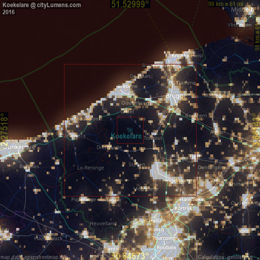
Analysis of Koekelare night lights 2016
Square area 10x10 km:
 0%
0%90-99
0%80-89
0%70-79
0%60-69
0.53%50-59
0.27%40-49
0.53%30-39
0%20-29
1.87%10-19
0.8%0-9
95.99%Square area 50x50 km:
3.38%90-99
4.07%80-89
2.29%70-79
2.09%60-69
2.54%50-59
3.17%40-49
3.21%30-39
4.55%20-29
9.36%10-19
18.89%0-9
46.46%Clear (daylight) street map image can be seen on geolist.org.
Map coordinates:
51° 31' 48" North, 2° 16' 30.6" East
51° 5' 25.7" North, 2° 58' 41.9" East
50° 38' 48.2" North, 3° 40' 53.1" East
Some cities around Koekelare sort by population:
• Zedelgem
12.5 km =7.8 mi,  62°
62°
• Torhout
9 km =5.6 mi,  107°
107°
• Diksmuide
10.3 km =6.4 mi,  231°
231°
• Ichtegem
2.7 km =1.7 mi,  77°
77°
• Kortemark
8.1 km =5 mi,  147°
147°
• Gistel
7.4 km =4.6 mi,  352°
352°
• Houthulst
12.6 km =7.8 mi,  188°
188°
• Oudenburg
10.6 km =6.6 mi,  8°
8°
2794194 (p: 8,317)
Sources (retrieved 2019-11-25):
» Earth at Night: Flat Maps 2012, 2016