Torhout night lights from space
Night Light of Torhout (Flanders) from space (Belgium) Src. Average luminocity for 10x10km area is 18.8249% and for 50x50km: 27.2062%.
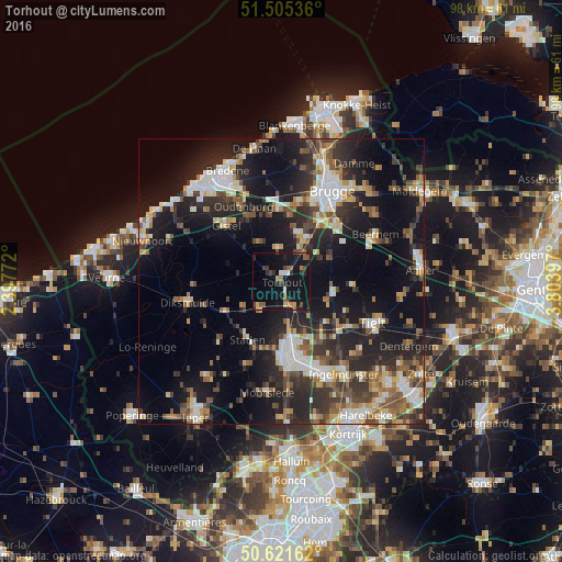
Analysis of Torhout night lights 2016
Square area 10x10 km:
 1.07%
1.07%90-99
1.07%80-89
0.67%70-79
2.81%60-69
2.14%50-59
4.14%40-49
3.74%30-39
3.21%20-29
4.41%10-19
34.22%0-9
42.51%Square area 50x50 km:
3.76%90-99
4.61%80-89
2.79%70-79
2.69%60-69
3.22%50-59
4.3%40-49
3.82%30-39
5.13%20-29
9.92%10-19
20.73%0-9
39.05%Clear (daylight) street map image can be seen on geolist.org.
Map coordinates:
51° 30' 19.3" North, 2° 23' 51.8" East
51° 3' 56.2" North, 3° 6' 3.1" East
50° 37' 17.8" North, 3° 48' 14.3" East
Some cities around Torhout sort by population:
• Zedelgem
8.9 km =5.5 mi,  16°
16°
• Ichtegem
6.8 km =4.2 mi,  299°
299°
• Wingene
12.1 km =7.5 mi,  94°
94°
• Kortemark
5.8 km =3.6 mi,  226°
226°
• Staden
11.8 km =7.3 mi,  210°
210°
• Hooglede
9.2 km =5.7 mi,  187°
187°
• Koekelare
9 km =5.6 mi,  287°
287°
• Lichtervelde
5 km =3.1 mi,  136°
136°
2785364 (p: 18,933)
Sources (retrieved 2019-11-25):
» Earth at Night: Flat Maps 2012, 2016