Gistel night lights from space
Night Light of Gistel (Flanders) from space (Belgium) Src. Average luminocity for 10x10km area is 23.6243% and for 50x50km: 21.3204%.
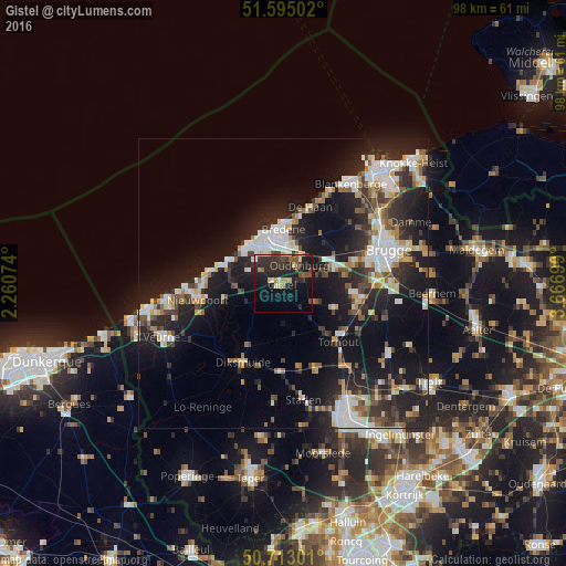
Analysis of Gistel night lights 2016
Square area 10x10 km:
 0.94%
0.94%90-99
1.87%80-89
4.28%70-79
1.87%60-69
1.74%50-59
4.01%40-49
3.48%30-39
6.42%20-29
17.91%10-19
20.45%0-9
37.03%Square area 50x50 km:
3.63%90-99
4%80-89
1.99%70-79
1.91%60-69
2.12%50-59
2.55%40-49
2.39%30-39
3.29%20-29
8.64%10-19
18.38%0-9
51.11%Clear (daylight) street map image can be seen on geolist.org.
Map coordinates:
51° 35' 42.1" North, 2° 15' 38.7" East
51° 9' 22" North, 2° 57' 49.9" East
50° 42' 46.8" North, 3° 40' 1.2" East
Some cities around Gistel sort by population:
• Ostend
7.1 km =4.4 mi,  338°
338°
• Zedelgem
12.2 km =7.6 mi,  97°
97°
• Middelkerke
10.5 km =6.5 mi,  288°
288°
• Bredene
8.8 km =5.5 mi,  5°
5°
• Ichtegem
7.6 km =4.7 mi,  151°
151°
• Jabbeke
9.2 km =5.7 mi,  71°
71°
• Oudenburg
4.1 km =2.5 mi,  38°
38°
• Koekelare
7.4 km =4.6 mi,  172°
172°
2797517 (p: 11,084)
Sources (retrieved 2019-11-25):
» Earth at Night: Flat Maps 2012, 2016