Habay-la-Vieille night lights from space
Night Light of Habay-la-Vieille (Wallonia) from space (Belgium) Src. Average luminocity for 10x10km area is 2.7968% and for 50x50km: 7.9044%.
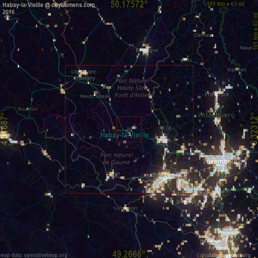
Analysis of Habay-la-Vieille night lights 2016
Square area 10x10 km:
 0%
0%90-99
0%80-89
0.53%70-79
0.8%60-69
0.53%50-59
0%40-49
0.67%30-39
1.2%20-29
1.6%10-19
0%0-9
94.65%Square area 50x50 km:
1.21%90-99
1.34%80-89
1.05%70-79
0.88%60-69
0.72%50-59
0.86%40-49
1.01%30-39
1.3%20-29
3.06%10-19
5.08%0-9
83.5%Clear (daylight) street map image can be seen on geolist.org.
Map coordinates:
50° 10' 32.6" North, 4° 55' 0.7" East
49° 43' 23.8" North, 5° 37' 12" East
49° 15' 59.8" North, 6° 19' 23.2" East
Some cities around Habay-la-Vieille sort by population:
• Arlon
14.8 km =9.2 mi,  107°
107°
• Aubange
21.9 km =13.6 mi,  142°
142°
• Virton
18.4 km =11.4 mi,  200°
200°
• Messancy
20.4 km =12.7 mi, 135°
• Neufchâteau
18.6 km =11.6 mi,  314°
314°
• Florenville
22.6 km =14 mi,  263°
263°
• Étalle
5.7 km =3.5 mi,  194°
194°
• Redange-sur-Attert, LU
19.9 km =12.4 mi,  76°
76°
2796807 (p: 7,704)
Sources (retrieved 2019-11-25):
» Earth at Night: Flat Maps 2012, 2016