Redange-sur-Attert night lights from space
Night Light of Redange-sur-Attert (Redange) from space (Luxembourg) Src. Average luminocity for 10x10km area is 2.6163% and for 50x50km: 12.5571%.
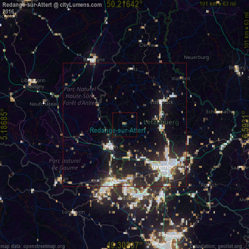
Analysis of Redange-sur-Attert night lights 2016
Square area 10x10 km:
 0%
0%90-99
0%80-89
0%70-79
0.53%60-69
1.07%50-59
0%40-49
0%30-39
1.74%20-29
0.13%10-19
1.2%0-9
95.32%Square area 50x50 km:
2.24%90-99
2.31%80-89
0.98%70-79
1.05%60-69
1.16%50-59
1.21%40-49
1.46%30-39
2.41%20-29
5.1%10-19
10.62%0-9
71.45%Clear (daylight) street map image can be seen on geolist.org.
Map coordinates:
50° 12' 59.1" North, 5° 11' 12.7" East
49° 45' 51.7" North, 5° 53' 23.9" East
49° 18' 29.1" North, 6° 35' 35.2" East
Some cities around Redange-sur-Attert sort by population:
• Arlon, BE
10.4 km =6.5 mi,  210°
210°
• Habay-la-Vieille, BE
19.9 km =12.4 mi,  256°
256°
• Messancy, BE
19.8 km =12.3 mi,  194°
194°
• Ettelbruck
17.9 km =11.1 mi,  58°
58°
• Strassen
20.7 km =12.9 mi,  140°
140°
• Bertrange
20.6 km =12.8 mi,  145°
145°
• Mamer
18 km =11.2 mi, 147°
• Mersch
15.6 km =9.7 mi,  96°
96°
2960160 (p: 1,164)
Sources (retrieved 2019-11-25):
» Earth at Night: Flat Maps 2012, 2016