Virton night lights from space
Night Light of Virton (Wallonia) from space (Belgium) Src. Average luminocity for 10x10km area is 9.2633% and for 50x50km: 5.9073%.
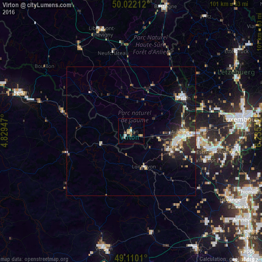
Analysis of Virton night lights 2016
Square area 10x10 km:
 1.4%
1.4%90-99
0.84%80-89
2.1%70-79
1.26%60-69
1.4%50-59
1.4%40-49
0.28%30-39
1.4%20-29
0.56%10-19
0.7%0-9
88.66%Square area 50x50 km:
0.82%90-99
0.92%80-89
0.84%70-79
0.56%60-69
0.41%50-59
0.59%40-49
0.83%30-39
0.93%20-29
2.52%10-19
4.66%0-9
86.93%Clear (daylight) street map image can be seen on geolist.org.
Map coordinates:
50° 1' 19.6" North, 4° 49' 46.1" East
49° 34' 5.7" North, 5° 31' 57.3" East
49° 6' 36.4" North, 6° 14' 8.6" East
Some cities around Virton sort by population:
• Aubange
19.6 km =12.2 mi,  90°
90°
• Longwy, FR
17.3 km =10.7 mi,  107°
107°
• Mont-Saint-Martin, FR
18.3 km =11.4 mi,  98°
98°
• Habay-la-Vieille
18.4 km =11.4 mi,  20°
20°
• Messancy
20.8 km =12.9 mi,  82°
82°
• Longuyon, FR
15 km =9.3 mi,  159°
159°
• Florenville
21.8 km =13.5 mi,  312°
312°
• Étalle
12.7 km =7.9 mi, 22°
2784555 (p: 11,259)
Sources (retrieved 2019-11-25):
» Earth at Night: Flat Maps 2012, 2016