Florenville night lights from space
Night Light of Florenville (Wallonia) from space (Belgium) Src. Average luminocity for 10x10km area is 0.8984% and for 50x50km: 2.2069%.
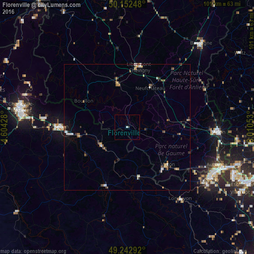
Analysis of Florenville night lights 2016
Square area 10x10 km:
 0%
0%90-99
0.53%80-89
0%70-79
0%60-69
0%50-59
0%40-49
0.53%30-39
0%20-29
0%10-19
0.53%0-9
98.4%Square area 50x50 km:
0.24%90-99
0.24%80-89
0.26%70-79
0.28%60-69
0.33%50-59
0.42%40-49
0.25%30-39
0.45%20-29
0.44%10-19
0.64%0-9
96.46%Clear (daylight) street map image can be seen on geolist.org.
Map coordinates:
50° 9' 8.9" North, 4° 36' 15.4" East
49° 41' 59.4" North, 5° 18' 26.6" East
49° 14' 34.5" North, 6° 0' 37.9" East
Some cities around Florenville sort by population:
• Sedan, FR
26.4 km =16.4 mi,  270°
270°
• Virton
21.8 km =13.5 mi,  132°
132°
• Bertrix
17.8 km =11.1 mi,  347°
347°
• Habay-la-Vieille
22.6 km =14 mi,  83°
83°
• Neufchâteau
18.2 km =11.3 mi,  30°
30°
• Bouillon
20.2 km =12.6 mi,  301°
301°
• Étalle
21.3 km =13.2 mi,  97°
97°
• Paliseul
25.8 km =16 mi,  331°
331°
2798272 (p: 5,464)
Sources (retrieved 2019-11-25):
» Earth at Night: Flat Maps 2012, 2016