Comblain-au-Pont night lights from space
Night Light of Comblain-au-Pont (Wallonia) from space (Belgium) Src. Average luminocity for 10x10km area is 2.2983% and for 50x50km: 18.4715%.
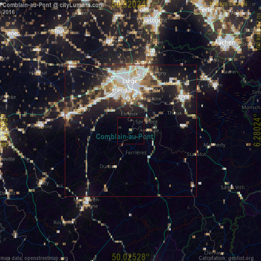
Analysis of Comblain-au-Pont night lights 2016
Square area 10x10 km:
 0%
0%90-99
0%80-89
0%70-79
0.7%60-69
0.42%50-59
0%40-49
0%30-39
0.56%20-29
1.12%10-19
0.56%0-9
96.64%Square area 50x50 km:
3.52%90-99
4.04%80-89
1.59%70-79
1.6%60-69
2.05%50-59
2.5%40-49
2.57%30-39
2.76%20-29
4.95%10-19
11.45%0-9
62.97%Clear (daylight) street map image can be seen on geolist.org.
Map coordinates:
50° 55' 12.9" North, 4° 52' 26.4" East
50° 28' 29.6" North, 5° 34' 37.6" East
50° 1' 31" North, 6° 16' 48.9" East
Some cities around Comblain-au-Pont sort by population:
• Seraing
13.2 km =8.2 mi,  336°
336°
• Chaudfontaine
12.7 km =7.9 mi,  18°
18°
• Esneux
6.8 km =4.2 mi,  354°
354°
• Sprimont
7 km =4.3 mi,  56°
56°
• Aywaille
7.1 km =4.4 mi,  90°
90°
• Durbuy
16 km =9.9 mi,  212°
212°
• Trooz
13.5 km =8.4 mi,  38°
38°
• Nandrin
11.7 km =7.3 mi,  287°
287°
2800204 (p: 5,308)
Sources (retrieved 2019-11-25):
» Earth at Night: Flat Maps 2012, 2016