Aywaille night lights from space
Night Light of Aywaille (Wallonia) from space (Belgium) Src. Average luminocity for 10x10km area is 8.2577% and for 50x50km: 17.4165%.
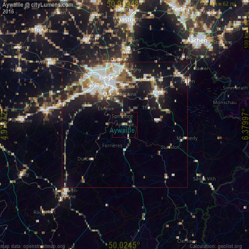
Analysis of Aywaille night lights 2016
Square area 10x10 km:
 0.28%
0.28%90-99
0.98%80-89
0.42%70-79
0%60-69
1.26%50-59
3.22%40-49
1.12%30-39
0.98%20-29
1.96%10-19
2.66%0-9
87.11%Square area 50x50 km:
3.43%90-99
3.96%80-89
1.54%70-79
1.49%60-69
1.86%50-59
2.32%40-49
2.33%30-39
2.45%20-29
4.24%10-19
10.76%0-9
65.62%Clear (daylight) street map image can be seen on geolist.org.
Map coordinates:
50° 55' 10.1" North, 4° 58' 25.4" East
50° 28' 26.8" North, 5° 40' 36.6" East
50° 1' 28.2" North, 6° 22' 47.9" East
Some cities around Aywaille sort by population:
• Chaudfontaine
12.5 km =7.8 mi,  345°
345°
• Esneux
10.3 km =6.4 mi,  311°
311°
• Sprimont
4.1 km =2.5 mi,  342°
342°
• Theux
11.6 km =7.2 mi,  55°
55°
• Spa
13.5 km =8.4 mi,  85°
85°
• Pepinster
14.3 km =8.9 mi,  39°
39°
• Trooz
10.8 km =6.7 mi,  6°
6°
• Comblain-au-Pont
7.1 km =4.4 mi,  270°
270°
2802837 (p: 10,636)
Sources (retrieved 2019-11-25):
» Earth at Night: Flat Maps 2012, 2016