Waremme night lights from space
Night Light of Waremme (Wallonia) from space (Belgium) Src. Average luminocity for 10x10km area is 19.6965% and for 50x50km: 25.0361%.
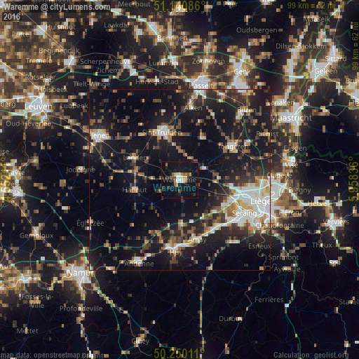
Analysis of Waremme night lights 2016
Square area 10x10 km:
 1.47%
1.47%90-99
3.34%80-89
1.2%70-79
1.74%60-69
2.14%50-59
1.87%40-49
2.81%30-39
4.28%20-29
3.48%10-19
31.68%0-9
45.99%Square area 50x50 km:
3.41%90-99
4.06%80-89
1.84%70-79
2.32%60-69
2.91%50-59
3.18%40-49
4.38%30-39
4.59%20-29
8.36%10-19
25.26%0-9
39.68%Clear (daylight) street map image can be seen on geolist.org.
Map coordinates:
51° 8' 27.1" North, 4° 33' 7.6" East
50° 41' 51.4" North, 5° 15' 18.9" East
50° 15' 0.4" North, 5° 57' 30.1" East
Some cities around Waremme sort by population:
• Landen
13.6 km =8.5 mi,  296°
296°
• Hannut
12.8 km =8 mi,  256°
256°
• Borgloon
13.5 km =8.4 mi,  27°
27°
• Gingelom
10.2 km =6.3 mi, 303°
• Heers
7.1 km =4.4 mi, 27°
• Villers-le-Bouillet
13.4 km =8.3 mi,  178°
178°
• Braives
12.4 km =7.7 mi,  224°
224°
• Remicourt
5.4 km =3.4 mi,  110°
110°
2784066 (p: 13,737)
Sources (retrieved 2019-11-25):
» Earth at Night: Flat Maps 2012, 2016