Amay night lights from space
Night Light of Amay (Wallonia) from space (Belgium) Src. Average luminocity for 10x10km area is 38.5709% and for 50x50km: 19.5321%.
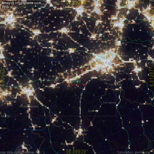
Analysis of Amay night lights 2016
Square area 10x10 km:
 4.55%
4.55%90-99
5.21%80-89
4.28%70-79
4.95%60-69
4.68%50-59
7.09%40-49
6.28%30-39
6.02%20-29
22.19%10-19
31.02%0-9
3.74%Square area 50x50 km:
3.19%90-99
3.73%80-89
1.62%70-79
1.86%60-69
2.05%50-59
2.57%40-49
3.12%30-39
3.45%20-29
5.65%10-19
13.89%0-9
58.87%Clear (daylight) street map image can be seen on geolist.org.
Map coordinates:
50° 59' 34.7" North, 4° 36' 23.8" East
50° 32' 53.8" North, 5° 18' 35.1" East
50° 5' 57.8" North, 6° 0' 46.3" East
Some cities around Amay sort by population:
• Seraing
14.1 km =8.8 mi,  73°
73°
• Flémalle-Haute
11.1 km =6.9 mi,  58°
58°
• Huy
6.3 km =3.9 mi,  239°
239°
• Wanze
7.2 km =4.5 mi,  261°
261°
• Villers-le-Bouillet
4.8 km =3 mi,  312°
312°
• Engis
7.3 km =4.5 mi, 59°
• Nandrin
9 km =5.6 mi,  120°
120°
• Marchin
10.2 km =6.3 mi,  207°
207°
2803246 (p: 13,307)
Sources (retrieved 2019-11-25):
» Earth at Night: Flat Maps 2012, 2016